While we were away for
Campsgiving in mid-October, we did a couple of side trips using
Sauble Falls Provincial Park as our base camp. This was our most ambitious, and it occurred on the first full day of our trip (Tuesday, October 15th - we arrived and set up camp on the afternoon of Monday the 14th) as that seemed to be the day with the best weather.
 |
| Which was still not amazing, but much drier than we expected the rest of the week to be. |
You see,
Tanker had never seen
one of the most stunning features of the
Bruce Peninsula, nor done much exploring along the northern end of the
Bruce Trail. We loaded up a pack and a couple of sets of trekking poles, tied on our hiking boots, and drove an hour or so north to
Bruce Peninsula National Park to start our adventure.
 |
| Not the most inspiring name for a place, but logging history is logging history. |
 |
| They're building what appears to be a lovely new visitor facility here, but for the time being there are only portajohns at the construction site and the composting toilets at the junction with the Bruce Trail. |
There is a charge of $11.70 (CAD, including tax) for parking at the Halfway Log Dump lot - you can pay by cash (deposit exact change in an envelope), or they have the old-fashioned carbon paper slips for making an impression of a credit card. Your parking permit is a bit of green paper with adhesive at the top. On a cool day (the predicted high was 12c, and I'm not sure it made it, though Tobermory apparently hit 12.8c) the adhesive will definitely meld semi-permanently with your windshield if you use it to stick the permit on the inside. Maybe one of these days we'll bother to scrape it off with a razor blade..
We were later getting going than we'd hoped, setting off about 10mins before noon and knowing that sunset was around 6:40pm - I figured our whole journey would take us around 6 hours, so we were cutting it a bit close, especially as there were rain showers predicted that could slow us down significantly.
 |
| The 900m trail from the parking lot to the Bruce Trail is flat and groomed. |
 |
| Junction of the Bruce Trail - as long as you can read blazes, it would be difficult to get lost as signage is ample. |
 |
| Rocky path down to the cobble beach |
 |
| Some most welcome blue sky! |
There was a group of highschool students from Sarnia (!) down at the beach - they'd arrived around the same time we did and headed down while their adult trip leaders finished filling out the parking permit for their rental van. They were only going as far as Stormhaven, though, and we needed to get moving if we were going to complete our hike before sunset.
 |
| About a half kilometer west there are climbable boulders, but we hadn't brought crash pads. |
 |
| The sun belies the chill of the water at all times of the year. |
Back up to the trail junction,
Tank looked at the groomed trails and asked which way we were going. Oh, the look on his face when I pointed to the first of the white blazes heading west..
 |
This way.
Yes, really. Follow me. |
 |
| ..and up we go. |
The first kilometer or so of the trail crosses a couple of ridges with some interesting climbing and descending - we were very happy that the rain had so far held off, so things weren't muddy, nor the rock too slippery.
 |
| Tanker for scale - it's a bit of a hill. |
That's not to say my clumsy arse - wearing
hiking boots I'd just purchased 8 days beforehand and worn quite minimally, as I'd got an amazing deal from a
local outfitter and my old boots were in rather poor shape - was totally confident in spite of the dry conditions.
 |
| You better believe I did some butt slide descending. |
 |
| Not sketchy at all. Nope. |
I was also quite motivated to ensure we were off the trail well before dark. While we'd brought headlamps just in case, the occasional sheer drop right beside the trail was much more easily avoided in daylight.
 |
| Like RIGHT beside the trail. |
 |
| No soft landings down there. |
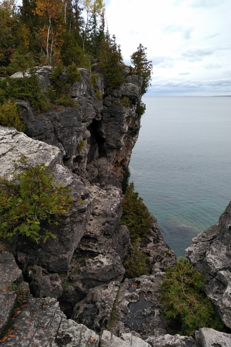
Traipsing along with our poles for confidence on the technical terrain, we came to the top of a ridge (which -
as previously discussed - is how you know you're done climbing on the
Bruce Trail) and found ourselves looking down at the clear waters of Georgian Bay.
 |
| So it was rather slow going over stuff like this. |
We just took our time, watching our step carefully, and enjoyed the views along the way.
 |
| I adore the colours in this photo, and it's even more impressively huge in person. |
As the trail turned back into the forest, we indulged in a bit of silliness.
 |
| I don't really condone vandalizing blazes, but I've gotta admit that's super cute. |
Not wanting to hold
Tanker the Mountain Goat back too much, I'd let him go ahead on some of the more technical descents.
 |
| There are a pair of composting toilets up top, and wooden tent platforms at the 8 sites |
 |
| This amazing cable-and-pulley bear hanging system is a strong encouragement to properly store attractants |
We didn't head down to check out the campground as I was starting to get concerned about time - I had made it clear that I reserved the right to call a halt and about face at any point if it looked like weather was setting in or we failed to reach our destination with enough time to make it back before sunset.
 |
| The fungus might have been right at home, but we weren't interested in staying the night. |
Around the 5km mark the trail turns sharply downhill toward the Bay.
 |
| With lots of loose stone underfoot |
 |
| Still having fun. |
You emerge at a cobble beach of bleached white stone.
 |
| First easy water access since Halfway Log Dump |
As we'd already polished off one full nalgene in the 2hrs we'd been on the trail, I pulled out a
lightweight water filter to replenish our supply. While many people are perfectly content to drink from Georgian Bay without filtering, I'm a little cautious. As a result, I'm happy to say I've avoided giardiasis (beaver fever) and cryptosporidosis in all my travels to date. I'm not saying I'd have been ill had I not bothered; just that it's very little effort to avoid the possibility of serious unpleasantness.
 |
| I also ended up testing the waterproofing of my new boots, which was fortunately up to the task. |
 |
My view as I sat and filtered.
It's not a black-and-white image - the desolate monochrome is natural. |
I filled the empty nalgene, drank some water straight through the filter, and then filled the 600ml soft flask attached to the filter itself before we set off again. I hoped that would give us enough water for the rest of our trip; we had a 4L bottle of fresh water waiting in the car for when we returned. We also had a snack - just a small fruit and nut bar each - to keep our energy levels up.
 |
| It's well blazed despite a dearth of trees. |
 |
| The signage is honestly incredible |
Despite it being a cool day in mid-October - not to mention the scant soil - we found some tiny flowers still in bloom.
 |
| Amazing |
We really had to mind our footing, though, as the rock beach's shifting terrain would make it easy to turn an ankle.
 |
| I took this photo by accident, but it shows the surface quite well with my heel for scale. |
 |
| Keep it upright, K. |
The Bruce Trail intersects the Georgian Bay/Marr Lake Trail, and we decided to take that route rather than follow the Bruce out to Halfway Rock Point.
 |
| Bench with an impressive rock formation on the Georgian Bay Trail |
 |
| You might be able to tell where we were heading...and also why we chose this path. |
 |
| Water safety sign - no danger of us wishing to swim today! |
Of course, this meant that we somewhat bypassed Indian Head Cove, only really seeing it from the west side.
 |
| Still incredibly impressive, though. |
We did stop to take a good look at the arch formation on the shoreline.
 |
| Nature is fascinating. |
 |
| Cold, cold water - even in summertime. |
A few minutes more - just shy of 3 hours after leaving Halfway Log Dump - we arrived at our goal.
 |
| This one. |
While some other people went down the chimney first - there were a surprising number there for such a chilly, overcast, October day - we sat and had sammiches above the tropical-looking water.
 |
| OMNOMNOM |
 |
| Don't lean forward too far.. |
 |
| As lunch views go, this one's a winner. |
Tank wolfed his sandwich down and went climbing up above the Grotto itself while I had a more leisurely meal.
 |
| If nothing else, daylight was wasting. |
 |
| It's quite an impressive view across the cove, as well. |
 |
| Tank was happy, I was happy - time to head back up. |
Now, we don't like to retrace our steps - though we wouldn't have a choice about the hike back - so we decided to climb up the cliff face in order to get back up to the trail.
One minor detail: in order to get to the best way to climb up, you have to traverse across the cove on a small shelf of rock.
 |
| You can just see a guy in blue on the other side - he sat on the ledge and shifted his bum along with his hands. |
Much as I'd have liked to sit and scooch, I now had the pack on my back, with the ends of Tank's trekking poles sticking up beside my head. They'd catch on the overhanging rock above the shelf, so I'd have to do the traverse in a more traditional rock climbing style - facing the cliff.
 |
| As Tank is doing here. |
So that's how my clumsy arse ended up clinging to limestone above the cold waters of Georgian Bay with no harness to catch me if I fell.
 |
| I was VERY aware of that while I moved. |
Fortunately the texture of the surface offered a lot of friction and plenty of positive hand and foot holds, so I made it across without splashing.
 |
| DIDN'T DIE |
 |
| Tank commencing his ascent to the top |
 |
| Back up on the trail |
Now at 3h28m from our departure (I kept my watch running throughout, so that includes our hydration, snack, water filtration, and lunch breaks), we turned our sights east and began our race against the setting sun.
 |
| Definitely did not want to try this after dark. |
The return trip - via the exact same route, as we were happy to make some easy time on the groomed Georgian Bay Trail before returning to the challenge of the Bruce - went fairly smoothly. We stopped less frequently for photos, and my boots had worn in enough to give me more confidence on the rocky sections.
 |
Though I almost fell backward climbing this steep section, grabbing and hugging this birch tree to save myself.
In return, it broke the strap of my fitness tracker. |
 |
| A brief hydration break at Cave Point |
 |
| Tanker was still having fun, and so was I! |
 |
| Darker skies toward Halfway Log Dump |
 |
| A front rolling toward us over the Bay |
Passing Stormhaven much more quickly than we expected, we started to see wet ground and rock - apparently we had missed a rain shower while we played at the Grotto, only getting a few drops on a handful of occasions throughout the day. We were very lucky, and I was very grateful as I'd been looking forward to this hike for months!
Had the weather been poor, we would probably have hiked a bit, then driven over to the day use lot that's a mere 30min easy stroll on groomed trail to get to the Grotto. In summer that lot is so jammed you actually have to book a 4-hour window in advance to use it, or stay at the Cyprus Lake campground and hike in from there.
 |
| I enjoyed this way much more. |
 |
| Even if all the sketchy climbs had become even sketchier descents (and vice versa) after the rain. |
 |
| The end of the technical trail, and well before dark! |
While I'd been a bit concerned when we only had three and a quarter hours before sunset when we left the Grotto, we made excellent time - our water (3.6L total, plus a few gulps direct from the filter) had lasted us so we didn't need to process any more, and we made fewer stops for photos.
 |
| Hey look - our car! |
Our return trip ended up being just two and a half hours, for a total round trip time of 5 hours and 56 minutes later - I guess my estimate of six hours was pretty solid! The distance ended up being somewhere around 14km; my GPS showed more than 15km, but it got a bit confused while we worked our way down the chimney and clambered around on the rocks.
It would have taken us significantly longer, though, had the rain rolled in sooner - we just had time to change out of our boots and have a quick post-hike snack before it started to dribble, and by the time we had rolled down Emmet Lake Road to Hwy 6 the skies had opened! It would also take more time in hot conditions, as we'd have had to stop more frequently to filter water.
 |
| We really had ideal conditions, and an amazing time! |
I'd highly recommend
the Grotto - whether you go the easy way or the hard way - at least once, if you're able. It truly is a sight to behold! The Bruce Trail is always worth checking out, too, at any point along its 885km length.


Gorgeous pics, but even looking at that chimney gave me anxiety! :O
ReplyDeleteIt's not really as narrow as it looks, and it's only enclosed up top. Then again, I'm kind of claustrophilic; always have loved tucking myself away in snug spaces!
Delete