After a motorcycle rally on the Labour Day long weekend and
racing then
volunteering at Wasaga Beach the weekend after, we took Saturday September 14th to pack the hell up and buggered off the next morning.
 |
Algonquin is Canada's oldest provincial park - est. 1893.
Yes, this beauty is 120 years old! |
Of course we arrived at
Canisbay Lake just as the rain was settling in. We pitched our
tent with a
tarp covering one end and making us a dry place to sit and cook, then ended up having to dig trenches to re-direct the torrent of rainwater that was flowing freely under the tent itself! Turn out we'd pitched on a natural drainage route, but a couple of trenches and some channels to catch basins (all dug with a
cathole trowel and a good-size branch) ensured a dry night.
 |
| Morning at Canisbay. |
Monday the 16th dawned with the last of the rain, and we were up around 9am. After french toast, sausages and packing up camp we made our final preparations and headed out for our true destination in the park - the first loop of the
Western Uplands Trail, located at kilometer 3.0 of the Frank McDougall Parkway (Highway 60), near the
West Gate.
 |
| Packs at the ready - mine on the left, Tanker's on the right. |
We didn't get going until about 2pm, and were going in the counter-clockwise (non-recommended) direction up the Eastern arm of the trail. I've done it in both directions, but Tanker had only seen the first section of the Eastern side on our last attempt in November 2004 - that trip was aborted by swampy conditions, freezing rain and general ill-preparedness. We were promised excellent weather this time, the trail had not just been subject to 5 days of rain, we were in much better condition fitness-wise (no longer smoking a pack a day!), and our gear has been upgraded significantly. We even brought a second
tent just for the trail, so we wouldn't be setting up a wet one!
 |
| Over the bridge and through the woods. |
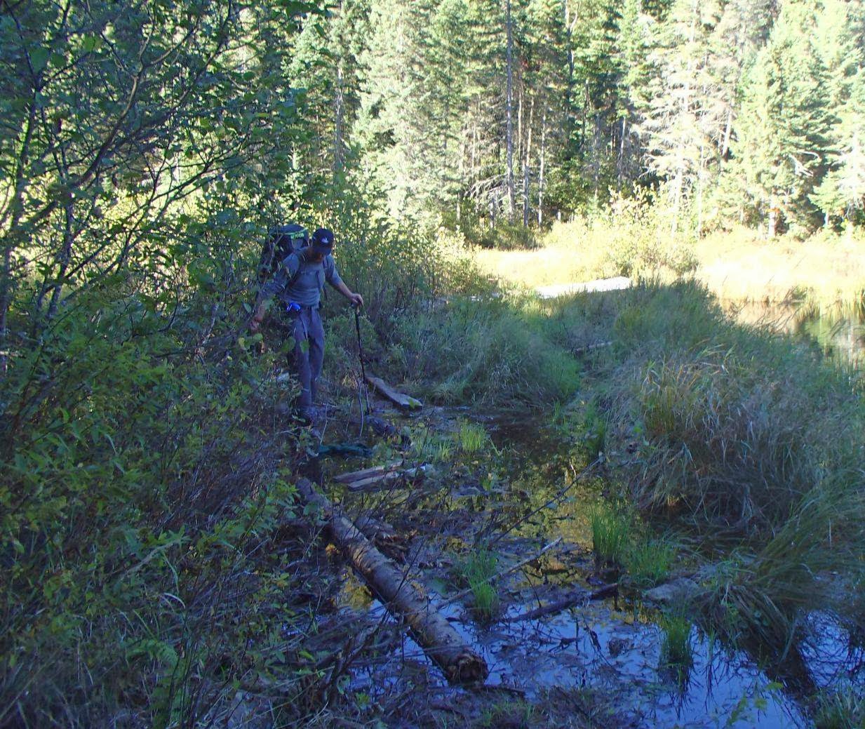
 |
| Pretty water crossing. |
 |
| Tanker contemplates an obstacle. |
 |
| Guskewau Lake - halfway point for the first day. |
 |
| Guskewau Creek |
We hiked approximately 8.6km out to Ramona Lake and set up camp around 5pm - the day had been beautifully sunny, if a bit cool with a high of 12c/54f. We'd only seen one group of 4 young lads on the trail, heading in the opposite direction (toward the trailhead); the ranger at the
West Gate who'd given us our permits had told us we'd be alone at Ramona that night, which suited us just fine. Even better - someone had left a fire already laid in the pit with a bit of wood beside it, so we'd have a cheery little blaze to warm up our little hollow by the lake! As the chill night drew in, though, we found ourselves crawling into the tent by 9pm. Real party animals!
 |
Our campsite at Ramona Lake.
It was one heck of a scramble up to the thunderbox! |
 |
Cooking up dinner - pasta with smoked salmon & fresh veggies.
We ate amazingly well on the trail with very few dehydrated foods. |
After a night that dipped to -3c/27f, we awoke around 8:30am to mist on the lake and a long day ahead. While the top of the 1st loop from Ramona Lake to Maggie Lake is not the longest section, it is the most challenging (at least in this direction) with a great number of steep, rocky climbs. First it was breakfast (scrambled egg, onion & bacon wraps with coffee) and filtering water from the glassy smooth lake, then packing up our campsite. We didn't get moving until almost 11:30am; something about cold mornings just makes it tough to get packed up and on the trail!
 |
| Mist on Ramona Lake in the morning. |
 |
| Going up. |
The weather warmed up significantly to about 17c/63f - while we left camp in our fleeces we ditched them in our packs at the first break we took, then got rid of our longjohns when we stopped for lunch, leaving us in pants and longsleeve merino wool shirts. It was a beautiful, sunny day to go traipsing through the woods and we made decent time until we came to the mess that was the Mink Creek crossing. The boardwalk itself was fine, but the 50-75m on either side were a ridiculous obstacle course of rotted, shifting logs that would roll and sink under you as you tried to use them as a bridge. It was only by the application of my trekking poles - one of which I had to lend to Tanker for the latter portion, seen below - and some luck that we managed to get through there without being launched into the swampy water. All of our packed items were dry bagged or in zipper baggies, but who wants to be soaking wet and smell like a bog? Our Gore-Tex boots also came in rather handy when the logs dipped below water level as they took our weight.
 |
| Tanker picking his way through Mink Creek. |
At last, after about 11.6km of hiking in a little less than 5 hours, we came to the side trail down to the campsites on the point at the Eastern end of Maggie Lake - a magical spot where I've always had an amazing time. We found another gentleman named Mike had got there ahead of us and taken the campsite on the North side of the point; in the strangest of coincidences, he was also from Cambridge, planned to stay the same 2 nights on the point and hike the loop of Maggie Lake on the day in between. He even intended to hike the loop in the same direction! What are the odds? Mike was friendly enough - we both offered any assistance or supplies that might be needed to each other - but since we were all there for the solitude that the shoulder seasons usually offer we didn't have that much interaction with him. We ate a delicious dinner of stir fry, then were back in our tent and headed for sleep by 9:30pm. Yep, wild and crazy once more!
 |
| Our first look at Maggie Lake |
 |
| Our campsite on the South side of the point. |
 |
| The island at the East end caught in the golden glow of the setting sun. |
Up around 8 in the morning after a much warmer night's sleep (it only got down to about 4c/39f), we had breakfast and headed back North along the main trail - actually moving in the correct direction for once! - until we hit the start of the circuit around the lake (which we did backwards as well). This particular loop hadn't been built the last time I did a non-aborted trip around the trail, so it was something new for us to discover together.
 |
| A lone red sugar maple flares brilliant red by Maggie Lake. |
 |
| Pretty dam crossing at the Western end. |
We had a pleasant little picnic of cinnamon raisin bagels with cashew butter and honey overlooking the South side of the lake before emerging back onto the main trail and heading back to camp. We'd left our site around 10:30am, and hiked the 8.5km (including a small detour as we walked right past the side trail to our campsite on the first go, then doubled back to it) in a little more than 4 hours with lots of stops for photos.
 |
| Lunch! |
 |
| Junction at the South end of the loop trail. |
Arriving back before 3pm, we had heaps of time in the warm afternoon for Tanker to collect and chop deadfall for another campfire while I sat down on a rock by the lake and filtered litre after litre of water to replenish our stores. By 7:30pm, after we'd eaten and prepped as much as we could for our journey back to the car in the morning, and the sky lit up with an incredible show for our last night on the trail. Between the amazing near-full moon and our lovely, warm fire we managed to stay up until around 10pm. Really burning the midnight oil, here.
 |
| Sunset over Maggie Lake. |
 |
| Coal bed from our fire - excellent way to finish our last night on the trail. |
We were up early (7:30) the next morning to have a quick breakfast of coffee and bagels before packing up and heading for the end of our backpacking adventure. We finally got moving at a decent hour - 9:30am - and set off to explore the prettiest portion of the trail. The night had been mild - around 8c/46f - and the day promised to be the warmest yet, so we set off in t-shirts with fleeces overtop and then ditched the fleeces an hour or so later!
 |
| Big deadfall - about 5.5' of clearance below. |
 |
| Wall of mossy rock. |
 |
| On the move. |
 |
| Little Hardy Lake |
We broke for lunch at noon after about 7km, stopping at a rocky spot near Maple Leaf Lake to brew up some
instant soup. We were making good progress - had only taken about 2.5 hours to do the first portion of our hike out, and the terrain gets easier to navigate the closer you get to the trailhead. We were both pleased to be within spitting distance of completing our challenge to ourselves and a bit sad to be leaving such a gorgeous trail behind!
 |
| North end of Maple Leaf Lake |
 |
| Trail soup! |
 |
| Pretty water spills |
 |
| The beginning of the fall colour peak |
After numerous stops to photograph beautiful sights along the way, we completed the last 12.7km Western arm of the first loop in around 5 hours, crossing over the bridge back to the parking lot and our waiting car around 2:30pm. Tanker was particularly elated to complete his first trip around the Southern loop - a total of 41.6km including the Maggie Lake circuit! It had come up very warm - we were sweating in t-shirts and trousers, and looked forward to setting up base camp so we could find our shorts again.
 |
| Finished and feelin' fine! |
 |
Sign at the trailhead.
"The trail is quite rugged and should be attempted only if you are in good physical condition" |
After a transporting snack of a fresh apple and banana from the cooler in our car (which stayed lovely and cold while we were gone, having been packed with ice and left tightly sealed), we drove up to
Mew Lake for 2 more nights of drive-in camping. We rigged up the faithful
Mutha Hubba tent - which had time to dry out from their soggy adventures at
Canisbay before we set up our sleeping pads & bags inside - and
tarp again, as rain was expected the following day. We built another fire, revelled in access to unlimited drinking water (no more filtering - there was a tap mere steps from our site!), enjoyed brushing our teeth and using a flush toilet at the comfort station, and had a fantastic sleep after a bit later night (11pm).
 |
| I don't believe in wearing pants before coffee. |
The next morning we rolled out of bed for a big breakfast of scrambled eggs and back bacon, then went paddling out of
Algonquin Outfitters' store on Lake Opeongo and hiked the rough-and-tumble 10.4km
Centennial Ridges trail before returning to our base camp, bringing our hiking mileage total up to 52km. It was a gray and windy day that threatened rain at every moment, but it held off long enough for us to do our day tripping, make dinner and get a good fire blazing before things got wet again - we actually kept the fire burning until we went to bed, burning through 2 full bags of wood! That night we were lucky enough to spot a red fox on our way back from the comfort station, and marvelled at the spectacle of a massive thunderstorm rolling in over the lake. It crashed and boomed around us as we stayed snug and dry under the tarp at our site, just proving that you can have an awesome time camping in any sort of weather if you prepare properly.
 |
| Tanker rockin' out as the rain begins to fall. |
We have hundreds more photos from our canoe & day hike adventures that I may get around to posting at some point - I haven't even had time to properly go through them all yet, having shot almost 600 in the 6 nights we spent in the park! After our return home on Saturday the 21st I launched straight back into the final bit of training for the
Run for the Toad 50k, including a 29km run on Sunday aa a last long run. With a couple of walks around our neighbourhood, that brought my total distance travelled by foot up to 97.6km for the week of Monday, September 16th to Sunday, September 22nd - now it's time to taper and hope I'm ready to take on the hills of
Pinehurst!


No comments:
Post a Comment
Go on, have at me!