While we had greatly enjoyed our time in Glen Nevis, we were looking forward to exploring more of the Highlands.
 |
| Particularly the imposing and spectacular Cuillins |
We were up relatively early Friday morning for brunch, and were on the road into Fort William by 10:15am or so - well before the 11am check-out time at
Glen Nevis. After 4 nights of fully serviced accommodations (our pitch had electrical hookups, and the comfort station in the park had excellent toilet and shower facilities), we planned to wild camp that night...but first there were other plans!
We stopped at the
Morrisons in Fort William to restock with groceries, as our next destinations would be decidedly more rural. I also needed to pick up some supplements: I hadn't brought anything with me to avoid any trouble with customs, but I have suffered from anaemia for ages and I was having real trouble kicking the fatigue from our adventures so far without iron tablets. I was happy to find some (plus some vitamin C + zinc tablets), along with the most wonderful assortment of gluten- and dairy-free foods. I will be having dreams about the gluten free baked goods I found at
Tesco and
Morrisons in Scotland for years to come!
We also found a tube of
Voltarol (the UK version of
Voltaren) for Tank - the poor lad's left leg was still incredibly painful after
our Ben Nevis climb 3 days prior. With our little fridge stocked up and a big bag of pantry goods, we hit the A830 west to make our way back out to Arisaig.
 |
| Past Bonnie Prince Charlie on his monument at Glenfinnan |
It was still a windy day, but much sunnier and warmer than Wednesday - we hoped the wind would cooperate so we could finally get in some paddling!
 |
| It was certainly no bother to see this scenery again, either |
 |
| Both the natural and man-made features are quite impressive |
Passing Loch Nan Uamh ("Lake of the Cave", if I'm not mistaken) - which had looked so angry in the howling west wind of two days prior - we noted with optimistic pleasure that it appeared much more congenial.
 |
Water levels also looked significantly lower
This was significant, as Loch Nan Uamh is what's known as a "sea loch" - similar to a fjord - open to the Atlantic ocean, which is essentially where we'd be kayaking.
 | | With a bit of luck, anyway. |
|
We arrived with plenty of time before our 1pm departure - enough time to make up a couple of egg salad sandwiches for lunch on a picnic table out front of the Arisaig Hotel and the Shellfish Shack.
 |
| It was about 13c and windy, but the sun was lovely and warm |
Our guide Stuart from Rockhopper Sea Kayaking arrived around 1pm, and we met the rest of our group: Morag and her two teen girls, and Gary with his lovely lady companion. As we had a short drive to our put-in spot, the girls (except me) all jumped in Morag's car, while Tank, Gary, and myself jumped in the van with Stuart to roll down the singletrack road toward Rhumach.
 |
| The sunshine and blue skies were unbelievable! |
Once stopped at our insertion point, Stuart distributed kit to all of us: waterproof paddling jackets, heavy nylon spray skirts, a paddle, and a lifejacket each.
 |
| Tank and I had brought our paddling gloves, Nalgenes, and waterproof phone pouches |
Gary and his lady elected to take the tandem kayak, while the rest of us would be paddling solo. We unloaded the boats and dragged them quite roughly across the rocky shoreline - I definitely would have treated them more gently! - then Stuart did a bit of kayak instruction before we launched.
 |
L-R: the girls, Morag, Gary's lady friend between Stuart and I, Gary, and Tank
(You can tell I'm amazing at remembering names) |
Stuart also explained that we'd be fighting the wind, but would have the tide helping carry us out: the lowest tide of the year, actually. Arisaig Sound would be quite shallow and the
skerries would be high and dry, which (he told us) would make for great paddling, as more wildlife tends to be about at low tide. We were soon off, and I was paddling around happily in the salty spray.
 |
| Tank took our waterproof camera with him |
 |
| I was shooting with my phone |
The wind was stiff and the sound was definitely choppy
 |
| Of course, waves never look like a thing in photos |
 |
| You'll just have to take my word for it |
Paddling out of Loch nan Ceall ("Lake of the Churches") toward the skerries, we could see the peaks of the Isle of Eigg and Isle of Rùm rising beyond the waves.
 |
| Slightly more impressive view than I'm used to, paddling my board on the Grand & Speed Rivers |
Once everyone was settled in and had got the hang of paddling, we headed upwind toward the skerries.
 |
| While mostly underwater at high tide, these low islands support a great deal of transient wildlife |
 |
| Following guide Stuart through some more sheltered water in the lee of the skerries |
45mins or so of paddling brought us to a sandy-looking island where we all pulled up and hopped out to stretch legs and have a look around.
 |
| L-R: Morag, Stuart, the girls, and Gary's lady companion |
I say sandy looking because the surface turned out not to be sand at all, but rather a substance called maerl - a type or seaweed or algae that deposits lime in its cell walls as it grows, leaving behind a brittle skeleton.
 |
| It crunches underfoot as you walk across it |
 |
| The skerry was all maerl, piles of seaweed, and projections of dark, volcanic rock |
 |
| Looking north toward Skye - there's usually still a bit of water in between these skerries, but the tide was at its lowest ebb |
While looking quite devoid of life, Stuart pulled aside some of the heaps of bladderwrack seaweed to find crabs of multiple sizes and species scuttling about beneath them.
 |
| That's my hand holding the teenytiny crab |
Gary made a discovery, too, wandering around by the boats - among all the empty oyster shells, he found a live scallop!
 |
| The classic cartoon mermaid bikini top shell - I'd never seen one in person before! |
Apparently they're edible raw, and Stuart and Gary had a go at convincing me to eat it...but I was a bit hesitant, as I wasn't sure if they were just having me on. In any case, the scallop was returned to the water to live out its little mollusc life for another day, and we returned to the kayaks to do some more exploring.
 |
| My trusty steed for the day |
 |
| I do not live in a part of the world where barnacles are a common sight |
The wind had slackened a bit while we wandered around the skerry, so we had a bit easier time pushing further northwest - it had been like work fighting wind and waves so far!
 |
| A little more settled now |
As we struck out further, we began to see more and more of something I'd hoped for when we originally planned this voyage.
 |
| I'd never seen seals in the wild before! |
The tide had turned now and was starting to flow back in - you could actually see the current it created in the water.
 |
| From its low ebb it would rise 4m/13' through the late afternoon and evening, and the skerries would all disappear |
Stuart offered anyone who wished to take their shot at paddling against the tide and the wind all at once, as he thought he'd seen some seals further out - Tanker and I were glad to take our chances, so we dug our paddle blades in to head due west. It was hard work, but within a few minutes we drew closer to a skerry absolutely covered in seals basking in the sun!
 |
| They're so funny on land - like big fuzzy bananas, awkwardly flopping about! |
As we came closer, many of them spooked and flopped their way into the water, where they were suddenly imbued with all of the agility and grace they lacked on land.
 |
| Though a few brave - or just lazy - seals remained to stare at us |
I turned back, feeling bad that we'd scared most of them off so the rest of our group wouldn't be able to see them...and then realized that Tank and I were the only ones who'd actually paddled out!
 |
| I'm so lucky to have a partner with whom to share adventures! |
To be fair, Tank and I were the only ones of our group (apart from our guide) who had years of paddling experience; everyone else had been happy to hang back and let us go do our thing. Now we turned our bows to the east and dropped our skegs in the water for an easy downwind cruise with the tide pulling us in.
 |
| Super laid back paddling now |
 |
| I was having a blast, but my shoulders were ready to get off the water! |
We took it easy on the way back to our extraction point - which I was fortunately able to spot, as Tank wasn't sure where it was until I pointed out some landmarks to him that guided us in - though we'd take a few sharp paddle strokes here and there to catch a wave and surf the boats a little. 20mins of cruising brought us back to the rocky beach, where we hopped out and pulled the boats up over the banks of seaweed almost exactly 2 hours after we'd departed.
 |
| Back to dry land! |
 |
| Soon all of this (except the green hills in the distance) would be underwater |
We stripped out of our soaked spray skirts, lifejackets, and paddling jackets, had a quick snack on the energy bars we'd brought along, then hopped in the van once more after all the boats were loaded up and secured. The short drive back to the Arisaig Hotel was a cheerful one as we'd all had a fantastic time, though unfortunately the Shellfish Shack was completely sold out once we returned. We chatted a bit with our fellow paddlers and guide Stuart, thanking him profusely for a lovely excursion, then changed up out of wet clothes and hopped in Mindy to get on our way.
 |
| Back along the stunning A830 |
While our intent was to head toward Skye, we'd chosen to do so the long way - rather than taking the ferry from Mallaig (just 20mins from Arisaig), we'd elected to do the much longer (~3hr) drive cross-country, figuring we'd get to see more that way.
 |
| ..not to mention avoid the £18 ferry cost |
This also took us back through Fort William for the sixth and final time.
 |
| With one last look at Ben Nevis - I think Tank's leg cramped at the sight! |
We struck north on the A82 from Fort William, making a stop near Spean Bridge at a suggestion I'd seen on google maps.
 |
| Now it was time to pay our respects |
The memorial was beautiful, and set in absolutely stunning surroundings.
 |
| The obligatory trig point decodes the peaks visible on all sides |
Possibly more poignant than the official memorial is the space provided for friends and family to leave their own personal memorials to loved ones who had served as Commandos.
 |
| A beautifully tended space just metres from the statue |
 |
| A tiny cross-section of the many plaques, berets, sculptures, and photos left in memory of those no longer among us |
While the sun was still shining brilliantly, the wind had turned cold as it swept through the Highlands around us, so we didn't linger too long before heading back to the van. It was already 6pm, and we still wanted to push on another hour and a half or so before stopping for the night.
 |
| So we left the three fine gentlemen to their lovely view |
We couldn't have asked for more beautiful views as we rolled north and west on the A87.
 |
| We feel like Scottish people will think our photos are faked due to the blue skies and golden sun! |
 |
| Loch Loyne shining like chrome |
 |
| If you stopped at every cairn, you'd take a year to travel 'round Scotland |
 |
| Near the Loch Cluanie viewpoint, with Sgurr Fhuaran ("Peak of Wells" or "Peak of Springs") and Beinn Fhada ("Long Mountain") rising in the distance |
 |
| We'd have loved to have Tank's kayak and my paddleboard for a traipse 'round Loch Cluanie |
We had originally planned to wild camp that night at a car park on Loch Duich, but our saltwater excursion of the afternoon left us both wanting a shower, so we decided to head to a caravan park instead that was approximately two whole minutes further up the road.
 |
| A dramatic entrance to the shore of Loch Duich - another sea loch, open to the ocean |
Fortunately, Ardelve Caravan & Camping Park was situated close enough to the car park we'd originally chosen to have a very similar view - and certainly one to which we are unaccustomed!
 |
| I can't think of a single other night of my life I've spent overlooking a castle |
We pulled in just after 7:30pm and paid £24 for a sea view pitch with electrical hookups (a £3 premium over the other electrical pitches in the small park), and I almost immediately headed off to the shower.
 |
| After gaping a bit at our view for the evening - Eilean Donan castle was as beautiful as its setting! |
The showers were on a metred system in small closet-like stalls with a door each opening to the outside of the low building at the top of the hill by the road, giving you about 10mins of water for 50p - just enough for me to have a good scrub up, and shampoo and condition my hair. Of course, I got lulled into a false sense of security, and went to give my ears another wash...only to have the water shut off just as I'd got them soaped up. Where there's a will there's a way, though: I was wearing sandals in the shower, and managed to pour the water out of each sandal on my ears to rinse them off! Tank had no problems, but then again he doesn't have a giant mop of hair to sort out and gets away with just a shampoo and soaping.
 |
| Sun setting just after 10pm over Loch Duich |
It was really quite chilly as the evening deepened, and we were glad to have warm clothes to put on after we'd both got cleaned up. I made us some dinner, then we went for a stroll along the shore, with the castle seeming to glow in the evening light.
 |
| We could never quite get our heads 'round it still being this light out at 10:30pm |
As what passes for darkness in the Highlands fell, we realized the glow was no illusion - the castle is lit by floodlights that surround it.
 |
| This is honestly one of my favourite photos from Scotland |
We awoke to glassy calm around 8:30am on Saturday, with hints of blue sky visible through the clouds.
 |
| Only the near-constant shrieking of seagulls disturbed the tranquility |
As Tank brewed up coffee and I cooked up some chicken sausage and eggs for breakfast, a sudden wind came howling down the loch, kicking up whitecaps within an hour after our serene rising. The lake was a tumult of waves, which then - an hour later, once the wind decided to go wandering elsewhere - then settled down once more. I wondered if Scottish people are all so friendly and helpful - as literally everyone we'd met so far had been absolutely lovely to us - because their country occasionally takes a whim to try to kill them? I couldn't imagine trying to plan a backcountry canoe trip or something when conditions could go from lovely to deadly and back again in a couple of hours.
 |
| And yet, I'd dearly love to try.. |
A lady with a western European accent (maybe German? Austrian? Swiss?) walking past on the path asked us if we'd seen them, and we asked what she meant as we'd no idea - she told us that dolphins had been seen swimming up the loch around 10am each morning, and she was looking for them. We hadn't, and kept looking until we were all snugged down and ready to pull out. No idea if she was pulling our leg or not, but we were a bit disappointed we hadn't seen any, nor any of the otters that apparently frequent the waters near Eilean Donan castle.
In any case, we got rolling just before 11am, setting a course west on A87 toward Kyle of Lochalsh.
 |
| ..where a certain bridge would take us to our next destination. |
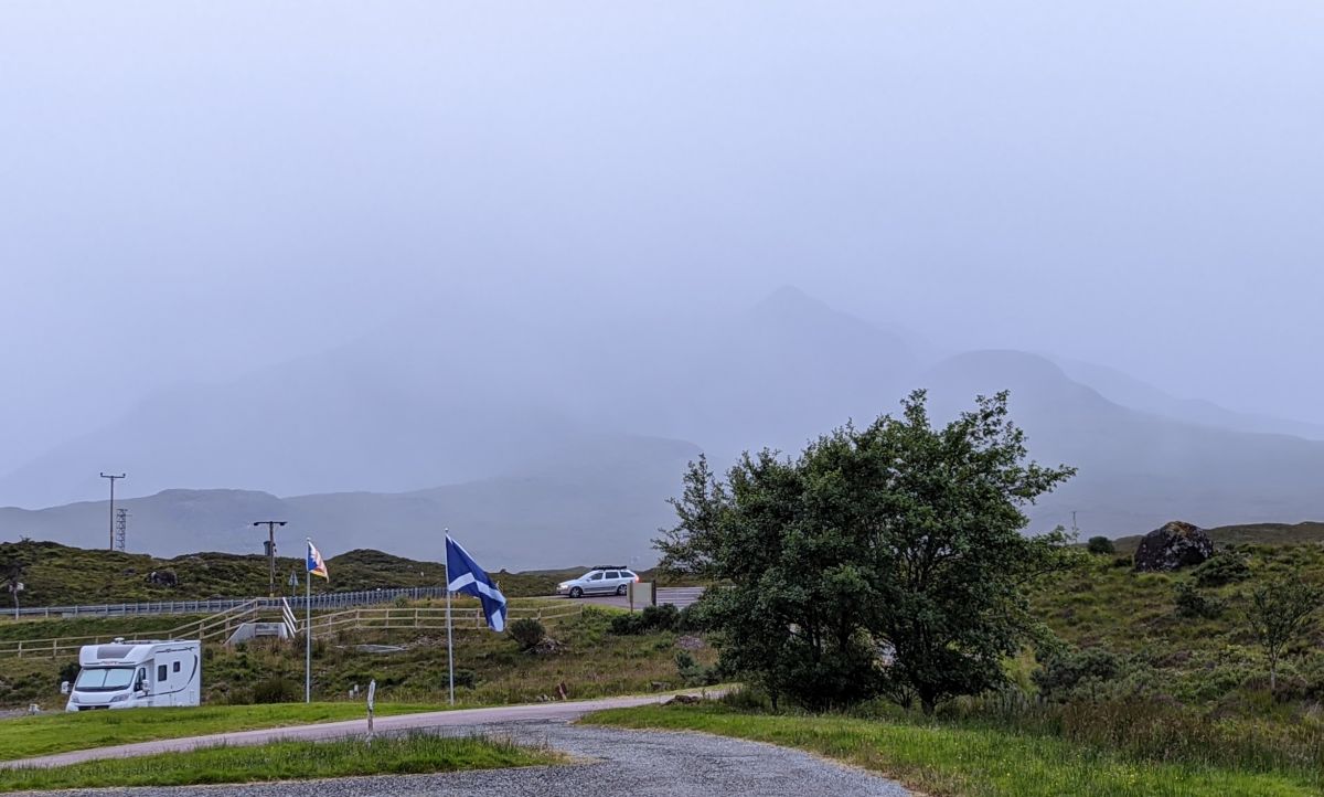
The clouds drew down in foreboding fashion as we got our first real looks at the Isle of Skye.
 |
Rising like a great, dark beast lurking on the far side of Loch Alsh
(View from Balmacara) |
The bridge itself is quite impressive, spanning the open mouth of Loch Alsh as it meets the Atlantic on either side of the tiny island
Eilean Bàn.
 |
| Just pulling onto the bridge out of Kyle of Lochalsh |
Onto the island itself, we finally made our first fuel stop in Broadford before carrying on.
 |
| Driving along Loch Ainort (I'm unable to find a proper translation - "ainort" seems to mean 'injustice") |
As we rolled along the A87, the Red Cuillins began to rise around us.
 |
| Their pink granite eroded by glaciers into cones and domes |
We drove through Sligachan, with the Black Cuillins looming to the south - we saw a gate across the driveway of the campground stating that check in was from 4pm-9pm, so we continued on our way west and south on smaller sideroads, with the last 20mins or so down to the Glenbrittle area on a winding singletrack with plenty of blind curves. While there was no cellular service on this part of the island, we were there to see something that only required good shoes and a camera to capture as much of the beauty as possible.
 |
| Photos can't really do it justice, but I'd do my best |
The car park for the Fairy Pools - at least the lower portion of it to which we were directed in our campervan - is pretty horrible. Lots of flinty rock sticking out of the gravel that seems like a real hazard to tyres, and lots of people wandering around through quite a narrow lot who seem like a real hazard to themselves. Nonetheless, we got parked up, paid our pittance of £6 for the privilege (and the on-site toilet facilities!), and got ourselves sorted out for a solid hike.
 |
| There's a long downhill to start, but that means you'll have to hike a long uphill on the way out |
We set off in misting rain, with wind whipping down the valley between the car park and the peaks of the Black Cuillins in the distance - Bidean Druim nan Ramh ("Peak of the ridge of the oars"), Bruach na Frìthe ("Slope of the Deer Forest"), Sgùrr nan Gillean ("Peak of the young men"), and Sgùrr na Banachdaich ("Milkmaid's Peak").
 |
| You can probably tell from my chosen apparel - tubular gaiter over my ears, and my new rain jacket over an insulated vest - that it wasn't the loveliest day |
The beautiful sights start right from the beginning of the trail, though.
 |
| This is only a 1min walk from the car park |
 |
| Technically this isn't really part of it, though |
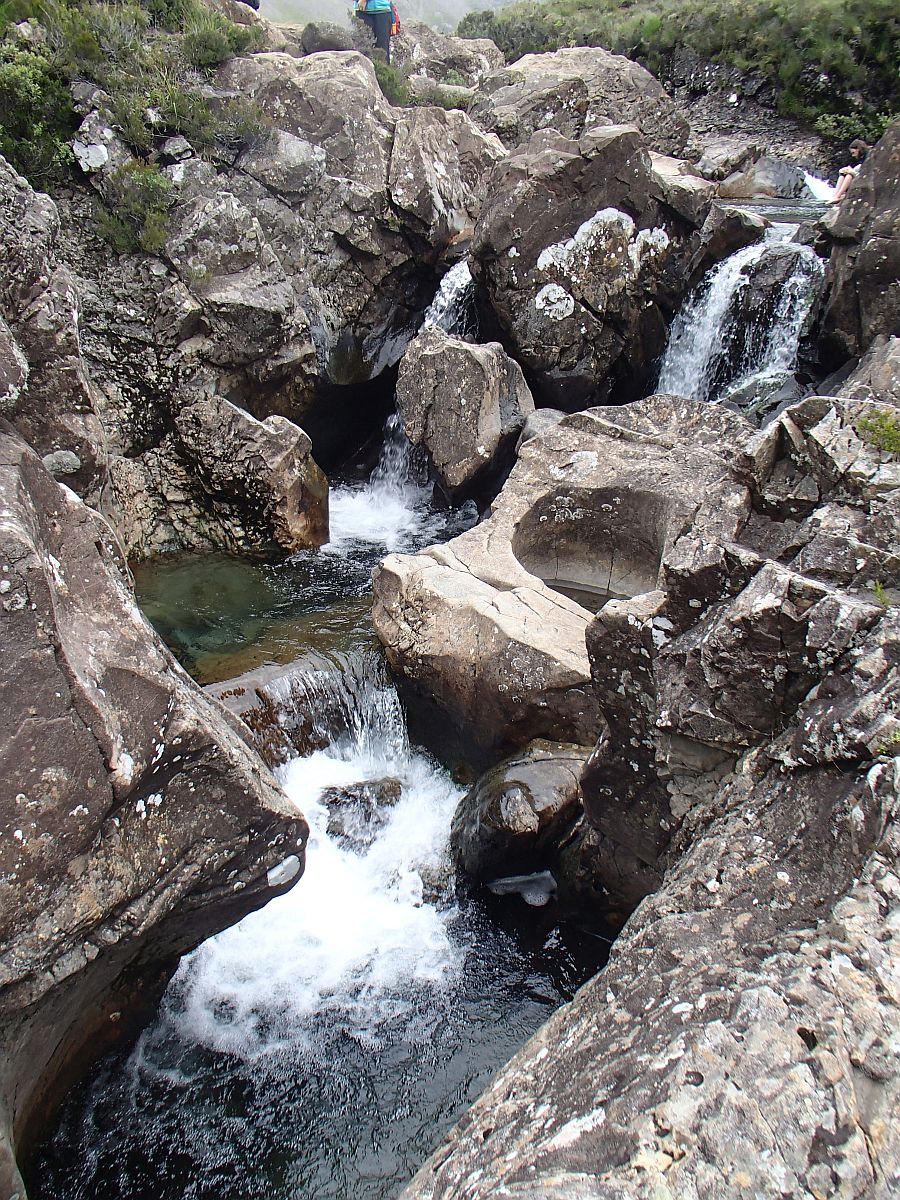
The Fairy Pools are essentially a series of waterfalls down the length of a river known as Allt Coir' a' Mhadaidh ("Burn of the corrie of the wolf/dog" where burn means river or stream, and a corrie is a cirque or cwm), also called the River Brittle (hence Glenbrittle) - the water is of an otherworldly clarity, swirling in pools of varying depths along the rocky bed between the varied falls.
 |
| After crossing a small footbridge, an increasingly rocky trail follows the river |
 |
| The Black Cuillins looking properly Scottish, though the misting rain had ceased |
 |
| There was quite a big lip of rock at the edge, with a knee-deep pool behind it |
 |
| The clarity of the water was amazing |
We saw some people swimming, but we hadn't brought swimsuits with us, and we weren't really keen on getting that chilled, so a wade was plenty for us.
 |
| It was quite busy despite the changeable weather - not totally surprising for a Saturday in July |
 |
| Still totally possible to have a lovely time, though! |
Tank - armed with our waterproof camera - went scrambling around on the rocks, as did I.
 |
| Tanker for scale |
 |
| Me astride a giant chunk of rock |
 |
| The iron content of the granite was quite evident in places |
The falls and pools went on for ages - if you plan to visit, make sure to give yourself plenty of time to explore!
 |
| There's so much to see |
 |
| ..even if the mountains were being a bit shy and hiding in the low cloud |
 |
| Believe me when I say it made them no less imposing! |
We were having great fun rambling around and exploring.
 |
| Tank hardly touched the actual trail |
 |
| He got loads of great photos from his vantage points on the granite |
I wasn't sure that the path had an actual end point to it - we'd seen a signpost near the start that said "Sligachan 4mi" so I suspected not - so when we came to a spot where it looked like we'd have to go quite a bit further to see any more falls, we stopped to have a good drink and a bit of a snack.
 |
| A bit more than 2km from the car park |
Refreshed, we turned around and began the hike back to the van, now straight into the feisty wind.
 |
| Poor Tank's leg was still in rough shape, but it was too beautiful for him to hang back! |
 |
| One last look back as the sun tried to peek out - you can just see the little footbridge past the first bend |
 |
| And not particularly good pavement |
Our next destination was Carbost on Loch Harport whic opens to the ocean on the west side of Skye. We were finally taking Tanker to his favourite distillery!
 |
| He'd been dreaming of this since we first decided to come to Scotland back in 2019! |
I'd carefully checked all sources I could find online, and everything said they were open 7 days a week from 10am to 5pm. Imagine our surprise - and poor Tanker's disappointment - when we arrived at 2:30pm to find a sign in the parking lot saying they were NOT open to visitors! I called later on (when we got somewhere with cell service) to see if they might reopen while we were still in the area, but it turned out that they had decided - after 192 years of business - that July 2022 was their time to undergo reconstruction, and they would be closed until August 6th!
 |
So this is as close as we got.
I felt so awful for Tank! |
I scrambled to see if there were any other distilleries on Skye that we could feasibly reach, but came up empty-handed. With much chagrin, we headed back to Sligachan (which means "a shellfishing place").
 |
| Lurking under the dark Cuillin Ridge |
We were back to town just after 3pm, so we decided to inquire at the hotel desk if they could tell us anything about how to register to camp - we had actually just heard the day before that the campground had reopened after two years of closures. The girl at the desk gave us the owner's telephone number, so I rang him up from the parking lot and was told to head on over: if the gate was in the way, just move it aside and pick a pitch, and the warden would be 'round by 4pm to sort out payment. Oh, and please re-place the gate once we'd pulled through!
 |
Now that's camping with a view! Glamaig ("Greedy woman") - the northernmost peak of the Red Cuillins - is one of two Corbetts on Skye, meaning a peak 2,500-2,999ft tall
(Munros are 3,000ft+), and stands over Loch Sligachan |
We pitched up above the combined shower, toilet, dishwashing, laundry, and registration building and had ourselves a late lunch while we waited for the warden to arrive.
 |
| Mindy happily plugged in for the next couple of days |
Once the young fellow turned up at the office we went and paid our £25 per night - cash only as they've no point of sale terminal - and then went out for another short walk to check out the old bridge and the Collier Mackenzie memorial. Reaching the hotel parking lot, we saw a cairn with a bronze plaque on it showing all of the hills we could see around us.
 |
With the peak of each worn smooth from the touches of many fingers through the years
Psalm 121 appears at the bottom in Gaelic and English -
"I to the hills will lift mine eyes, from whence doth come mine aid." |
As we crossed the road and found the entry to the peatlands, further plaques gave information about the region and the memorial.
 |
"Heroes and legends have brought Glen Sligachan's appeal to life throughout the ages. The sculpture ahead, created by artist Stephen Tinney, depicts two such figures. Skye born crofter, John Mackenzie from Sconser, is the seated figure. He was the first British professional mountain guide who was experienced to Alpine standards. The standing figure is Professor Norman Collie who went on to become a regular climbing client and life long friend of Mackenzie.
Together both men formed a prolific climbing partnership which lasted fifty years. As pioneers of the Cuillin they mapped and named many of the peaks.
When John Mackenzie died in 1933 aged 76, Norman Collie returned to Skye to see out the rest of his days. Collie died in 1942 aged 83. At his request, he was laid to rest beside his lifelong friend at a small cemetery near Struan on the west side of Skye, within viewing distance of the Cuillin." |
Another fascinating bronze sculpture stood nearby on a low cairn of its own.
 |
There was no information about it other than a simple engraving 'round the edge:
Isle of Skye in Bronze |
We did a bit more wandering along the River Sligachan
 |
| All the while agape at the mountains |
 |
| They seemed almost close enough to touch - just 'round the next bend in the river |
 |
| Built between 1810 and 1818 - a new bridge was built for the A87 |
We didn't linger too long, though, as we wanted to be well-rested, so we soon headed back to get out of the wind and off our feet.
 |
| I'm definitely glad we went and had a look, though |
The next day, we had business in the Cuillin Ridge that would test us to the utmost.
 |
| ..and the Cuillins did not look particularly welcoming. |
That is, when we could actually see them! As we returned to the van to make some dinner, the
dreich - which we'd so far avoided -
began to descend in earnest.
 |
| ..and the Cuillin Ridge began to disappear |
While it was still relatively clear over Loch Sligachan, it wasn't difficult to tell we'd be in for a wet night.
 |
| Especially since - for the first time since we'd arrived - the midgies were absolutely horrendous! |
There's just something about the Cuillins, though - even when they're so shrouded in mist that they're barely visible, their presence remains a near physical force looming over the tiny town.
 |
| We'd soon get a very close-up look...assuming we could find them! |
We'll take a break from the Scotland Saga next week for a bit of a chat about tomorrow's idiocy - I'm nowhere near in shape for a
50k, so let's see how well I can fake it!