When last we met, I mentioned we had big plans for our full day in Parc National due Fjord-du-Saguenay.
 |
Really. Big. Plans.
|
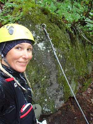
We were up quite early for a simple breakfast of oatmeal and bagels, trying to ensure we could get on the road as soon as possible. In the interest of safety, though, I had to spend some time stripping all the metal out of my head - no-one wants piercings catching on things.
 |
You're not alone - I'm weirded out, too.
|
I made us up some big sandwiches, made sure that we had everything we'd need stowed in a pack, then it was off we went to meet our fate.
 |
| In less than auspicious weather. |
It was hosing down rain - had been since about 2am. Of course the first downpour of the whole trip happens to be the day we have the most epic (and only booked-in-advance) activity planned.
 |
The fog through the fjords looked some kind of amazing, though.
|
All the way back west along Route du Fjord - retracing our steps from the day before - and across the Pont Dubuc spanning the Saguenay River.
 |
During a break in the rain
|
Then we rocked along the southern shore of the river for nearly another hour.
 |
| Under very angry-looking skies |
A blown turn in Rivière-Éternité (signage was not particularly clear), then on to the absolutely terrible pavement of Rue Notre Dame.
 |
It's kind of a pothole with occasional bits of road.
|
 |
You won't hear me complain about the scenery, though.
|
Almost 2hrs after departing camp, we arrived at the Baie-Éternité secteur of Parc National du Fjord-du-Saguenay at a little before 11:30am. We loaded up our gear in the parking lot, then walked the ~250m down a fairly steep hill to the Visitor Centre to check in for our via ferrata excursion. They'd re-started operations about a week before we departed, and despite having just blown out my back (best guess is a herniated disc) a few days beforehand, I booked right away for our one full day in the park.
It was my 41st birthday, and we were going to climb a freakin' mountain in the pissing rain.
 |
That one, as a matter of fact.
|
We got checked in ok, but then I realised my dumb arse had left my mask back at the car somehow. Tank tried to go get it for me, but I'd failed to put together that I'd left it in the pocket of the sweater I'd taken off (as I didn't wish to climb in it), so he couldn't find it. Fortunately the Visitor Centre gift shop had cloth masks made by a local seamstress in Anse Saint-Jean, so I was able to purchase one; it had elastic that was meant to go behind the head, making it less than ideal for wearing with a helmet, but a couple of moments with a knife and some knots fixed that.
 |
Call it a pandemic birthday present to myself?
|
The rain ceased again, and it almost looked as though the sun might come out as we met our guide Guillaume and got our equipment.
 |
| The wind was chilly and damp, though, so we donned our jackets as well as our harnesses and helmets. |
As we were given our instructions - ourselves, a girl from Montreal, and a pair of twentysomething kids (guy and girl) with maybe dad, maybe the cool uncle? - Guillaume told us we could actually see part of the parcours overtop of the Visitor Centre. The same peaks we'd been staring at earlier, pictured above.
 |
| There were even people out there climbing - see the yellow helmets by the ladder? |
 |
How about now?
(Same shot, just enlarged) |
Still with some trepidation - my back had been doing ok through the trip so far, but I wasn't sure how it would react to a lot of pulling and reaching, and the forecast was calling for a possibility of thundershowers as the afternoon went on - and with the rain having re-started, we set off on foot for a short hike to the departure point.
 |
Guillaume leads the way, followed by the girl from Montreal
|
 |
Tank and I, with the family bringing up the rear.
|
It was only a few minutes before we arrived at the training wall - a far cry from the
parcours at Mont Tremblant, at which you kinda have to climb via ferrata in order to reach the training wall - where Guillaume ran through all of the procedures and nomenclature in both French and English (Tanker and I being the only non-Francophones in our group).
 |
There are 3 variations - La Passerelle is rated "beginner" and starts from a different area, La Grande Dalle is rated "intermediate", and L'Odyssée (which we would attempt) is rated "advanced"
|
 |
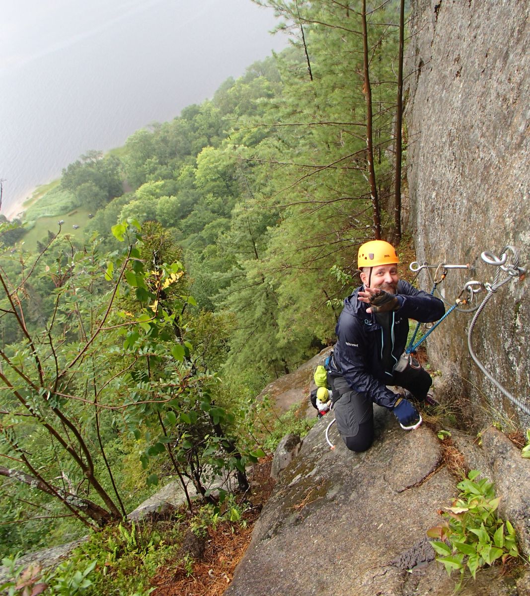
Guillaume in front of the training wall - see all the steel hardware and aircraft cabling?
|
 |
A little bit of forest love by the training wall
|
As Tank and I were the only ones who required instruction in English, we went last through the training wall - the final opportunity to chicken out and still get a refund (less a processing fee), per Sepaq's rules.
 |
| The family went first, and did just fine |
The rain was picking up again - our guide decided it was time for his shell jacket - and the steel hardware was slick in the wet, but the training wall went ok.
 |
| Tank showing his inner mountain goat |
With everyone having completed the entrance exam, it was time to move on to the parcours proper via another short hike.
 |
| The wet wood staircase was actually one of the sketchiest parts of the whole day, and there was nothing yet to clip into! |
 |
It's all up from here.
|
With Tank and I having the most via ferrata experience (this being our
fourth excursion), we were sent ahead to lead the group. No pressure, right?
I was remarkably ok with coming to a flatter, more trail-like section where the lifeline ended. Guillaume had shouted ahead to me to wait for the rest to catch up when I reached it, so I stopped for a drink of water from one of the nalgenes in my pack.
 |
| Loosely translated as the "Upstream Backwards Ladder" |
What - you may ask - in the heck is that? I didn't really know either, until we reached it - it was, however, the only feature we'd been able to see from outside the Visitor Centre.
 |
| Ok, so it's a ladder. |
What makes it "inverted" is that you approach facing the rock (up those rungs you see to the right), then turn yourself to climb the ladder facing out into the bay.
Yes, I am aware of a logical disconnect between being kinda terrified of ladders and blithely attempting to mountain goat my way up soaking wet mountains. Just roll with it, ok?
 |
And I do mean soaking wet.
|
Having reached another ledge - and another rescue box, where I'd been asked to wait as we regrouped - I took the opportunity to sit my butt down for a minute after a fairly long climb that had warmed me up quite a bit. I'd zipped down my jacket and pushed my sleeves up my forearms to get some cool air to my chest and wrists, but I wondered how well the thin fabric would hold up as I'd already caused some damage by banging my elbows off the mountain.
 |
| You know there's been some intensity in your life when this feels like a comfortable, secure place to chill. |
I was starting to feel the effects of the climb so far - my knuckles were getting torn up from dragging them along the wet rock while holding the lifeline (something I'd done more on this parcours than any other I've climbed; it's not recommended but the combination of sketchy, wet footing and some stretches bare of hardware left me feeling like I had no choice), and I was getting bruised all over from some imprecise movements that led to bits of me meeting stone or metal hardware in less than comfortable ways. I had a drink of water and thought about how far there still was to go; we were less than halfway through the parcours.
 |
| I think this is the only photo I have that actually shows everyone in our group. |
Once Tank had joined me, we had a snack of an energy bar each, then when we were given the OK from Guillaume we continued along our slightly battered way.
 |
Onward and upward
|
We'd started to reach some of the more familiar types of features on the route - apart from the usual hardware, every Sepaq parcours we've climbed has employed some interesting methods of spanning gaps in the rock face.
 |
Roughly translates to "steep rope bridge"
|
This is known as a monkey bridge - you clip your carabiners on the top line, which you also hold with your hands and you move your feet along the bottom line.
 |
Yes, it swings rather alarmingly. No, I didn't stop to take photos on it.
|
 |
| I did, however, stop just before the next feature at the behest of our guide. |
Strangely enough, I actually prefer the monkey bridges to the planks - you're encouraged to walk across these without using your hands.
 |
| The lifeline to the left is supposed to be for your carabiners only. |
I, however, am a clumsy oaf at the best of times, and wet wood is slippery as teflon, so you better believe I had a hand on the lifeline.
 |
| Get on with it, right? |
The wind had turned cold and the rain had - if anything - picked up by the time we reached another ledge.
 |
It may not be very wide, but it was a lot more secure than a wet bit of rebar.
|
I shot a few seconds of video so you can see exactly what the weather was like.
With all of the stopping to regroup, Tanker and I had lost all of the body heat we'd built up while on the longer upward climbs - we'd both pulled our sleeves down and zipped our jackets right up to our necks, but were still at the point of shivering in the gusts. I was also concerned about our exposure should the thundershowers they'd predicted for the afternoon come banging through, so we talked to Guillaume very seriously about the possibility of taking the trail down either one side or the other of the upcoming bridge (the same trails that are used by the Intermediate grade parcours: La Passerelle is basically just a hike up to the bridge, crossing it, then hiking back down again, while La Grande Dalle is follows the same route as L'Odysée until the far end of the bridge, then you hike down).
 |
Deep in discussion
|
Guillaume radioed to the shack (which I'm sure has some much more impressive, proper name, but I couldn't tell you what it is) for a weather report, and it seemed the thundershowers had been dropped from the forecast. The next question was a serious one: would we have to downclimb all the way back to ground level at the end of the parcours? Both Tank and I were starting to feel the multiple hours of effort in the cold and wet taking their toll on us, and downclimbing is (counter-intuitively) the most difficult part of via ferrata - you're less able to see holds while looking past your feet, and the motions are much more awkward even with gravity on your side.
 |
And we were rather a long way up..
|
After being reassured that it was a hiking trail that awaited us at the end of the lifeline, our concerns were (mostly) allayed and we continued onward.
One thing that struck me about this parcours was the number of places you'd come to a corner at which the rock seemed to end, and you'd have to have faith that there was something - anything - around that corner other than fresh air to step on.
 |
| One of which resulted in this rather epic photo of Tank |
Oh, and just because we wouldn't have to downclimb off the end of the route didn't mean we wouldn't have to do it at all; as we approached the bridge that is the jewel of this parcours, we needed to lose some altitude.
 |
| Left foot on that little diamondplate step, then down the ladder of rungs |
 |
| It was not an insignificant stretch. |
I came to a ledge, and thought it might be the end of the downclimb...but no, off the end of another ledge it was, down a set of wee rebar handles and diamondplate steps.
 |
So much gear to clip.
|
And then another corner to round, though it was pretty easy to see the large rebar rungs along which you could walk fairly steadily. I was actually quite impressed that my trail running shoes - an old pair of New Balance WT101 that I always use for via ferrata for some reason (mostly because they pack down small; easy to fit in a saddlebag when motorcycle touring, though we had the car with us this time) - had been fairly reliable on the wet steel. I'd been careful about my foot placement, but hadn't really had any slipping issues.
 |
| For which I was really grateful! |
One more ledge, at which Guillame asked us to stop to let the group come back together, and our first look at the bridge.
 |
| 85m / 279ft long, spanning a gap between two ridges |
 |
| We were now about 2/3 of the way through the parcours |
 |
| It passes by a waterfall, though it wasn't possible to get a very good view. |
Miraculously, it had finally stopped raining! When everyone had reached the ledge and Guillaume had explained the best way to move along it (clip carabiners to the lower of the two overhead lines, then walk with a hand on either side; one person per section of lifeline, and the usual "only unclip & move one carabiner at a time" when crossing into a new section), I got on my way.
 |
| You can just see the hardware separating two sections of lifeline slightly up and left of centre in this photo - every part of the parcours (climbs, descents, traverses) has its own restrictions on how much spacing to leave between climbers. |
Once I'd wandered out a ways on the bridge, I stopped and clipped on my rest carabiner to take a stinkin' selfie, because...well..it's me, innit?
 |
Dorking a hundred feet or so off the ground.
|
I'd actually stopped so I could get some pics of Tanker on the bridge, but I only got the one; so far I'd had a pretty easy go of it, despite the soggy, slippery wood planks below my feet. Once someone else was on the bridge with me, it started to sway much more and I simply concentrated on putting one foot in front of the other and not falling the heck off.
 |
| I was fortunate that I was able to make the crossing before more than 2 people entered the bridge behind me! |
The best vantage point for photos of how epic this bridge truly feels is from behind it, looking out to the Baie; I lifted this one from
the Sepaq site to give you a better idea of the scale.
 |
| You'll notice they show it on a sunny day. |
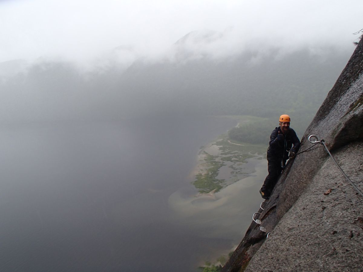
Off the bridge and back onto rock, which was still sopping wet even though the rain had passed. As we progressed through the final third of the parcours, there seemed to be a greater reliance on the rock itself for hand- and footholds, rather than emplaced hardware. Apart from length/duration, this seemed to be the determining factor in this being considered the "Advanced" route, rather than La Grande Dalle (rated "Intermediate") which ended in a downclimb and hike down from the bridge itself.
 |
The last portion also included this Nepalese bridge, which is basically just a line for each hand, one overhead to which to clip your carabiners, and one to walk along for your feet.
|
Knowing we were into the final stage of the parcours, I tried to be aware of my movements, as I could feel I was getting tired and didn't want to get sloppy and make an error that could lead to a fall.
 |
| Only into my harness, of course, but try convincing yourself of that after hours and hours on a rain-soaked mountain side. |
What was kind of messing with me, too, was that we suddenly heard what sounded like an owl call back along the parcours, and then one very close. It took me a few minutes (and a few more calls) to figure out that Guillaume was communicating with another guide, leading another group in behind ours.
 |
| Go ahead and see if you can spot their yellow helmets. I'll wait. |
With the freedom to move at my own pace I was not longer freezing (though certainly not warm, either), but fatigue was mounting and soreness was building - my arms and shoulders began to tell me stories of the things I'd made them do to haul my butt up this rock face, and my hands and wrists ached from endlessly clipping gear.
 |
| A nice stretch of rungs to walk up, but only the rock (or the lifeline) for your hands. |
To my own delight, as I climbed I noticed a scrubby little bush growing out of a crack in the stone: there were just a handful of tiny, wild blueberries, a few of which were ripe enough to eat.
 |
| I took two and left the rest, letting Tank know there were trail snacks for him if he wanted them! |
 |
| He seemed to appreciate the offer. |
By this point I was 100% ready to be done; we'd been on the rock for nearly 5 hours (the estimated time for completion of the whole outing is 6hrs, including the ~40min hike down), and I kind of hoped that each stretch would be the last. Straight talk: I had to pee SO FREAKIN' BADLY, and with no end in sight I asked Tank to let me know how far we were ahead of the girl from Montreal. He said she was a ways off, so I warned him to hang back a minute while I somehow managed to wriggle my trousers down inside my harness, and...well...the rock got a little wetter.
Sorry folks. Couldn't help myself. It was happening whether or not I made any accommodations, I was definitely more than 200ft from a water source, and I tried to make sure I didn't soak any parts of the mountain that anyone would have to touch.
 |
| And seriously, the parcours just kept going: I'd think I'd found the end, then I'd round a corner and see the gleam of steel hardware ahead. |
It was only about 10mins later, though, that I scrambled up on top of a ledge high above the bay and found the end of the road!
 |
| With - from what we could see - good reason! |
 |
| We made it! |
Tanker and I had a snack (we'd been advised to bring two per person, which we had diligently done) and drink of water to prepare for the long hike back to the shack, while the rest of our group completed the parcours.
 |
The tree to the right of this photo - beside the girl from Montreal - is the end of the lifeline.
Guillaume in his blue rain shell still looks cold, while Tank displays his thoroughly soaked mask. |
The lifeline had ended, but there was actually still one more bit of climbing; just a few rungs up a chunk of rock.
 |
| I guess they figured if you'd made it this far without dying, you could handle this without being clipped on. |
Then, to our delight, there was a portajohn available for use! I felt like a bit of an idiot for weeing on the mountainside, but I wouldn't have made it without soaking my trousers and the (borrowed) harness. We asked Guillaume how the heck they got the portajohn up there; was there a trail? Turns out nope - they'd airlifted it in while the parcours was under construction, some of which had to be completed by helicopter anyway. Damn fine ideas, those folks.
Once everyone that needed to had used the facilities, we started our descent on the "trail" - I mean, I've traipsed through some muddy, sketchy areas (Sulphur Springs 2017 & 2019, anyone?), but this was a little nuts.
 |
| You know you're in for some fun when your guide says "My god, I've never seen it so wet.." |
 |
| ..and then he just straight-up mountain goated it down the trail. |
He warned us before we set off that we needed to watch our step, as people often got hurt on their way down, even in fair weather. The 3 family members laughed at that a bit, but it's true: so often people have either pushed themselves so hard on the climb they're too tired to exercise the caution required on the descent, or have such a sense of already having accomplished their goal that they let their guard down. It would be easy to just lose yourself in the landscape, too - full of rushing streams, as all the rain that had fallen all day thundered down the mountain.
 |
| I don't think I've ever seen anything quite like it, and the sound was incredible. |
Guillaume told us stories of wolf and moose and bear spottings in the area as he marched along, sure-footed in a sturdy pair of hiking boots (the
website for via ferrata registration recommends "closed-toe shoes with a rather rigid sole"). I'm a dork, so I sang the a goofy song in French that I learned in grade 4...and then realized how many years ago that had been.
 |
| If I'm over the hill, how the heck am I still going up one? |
 |
| Oh look, pretty things (and sort of almost sunshine!) |
In one spot there was a rill of water just a bit too big and swift to cross safely on foot, so Guillaume and I moved a fallen log in as a makeshift bridge. We eventually reached a junction with a groomed path - it runs out to a monument in the park - at a massive glacial erratic boulder, the rear side of which I (ahem) examined closely for a moment, while others took a break to drink some water.
 |
| Yeah, I had to wee on the landscape again. All that running water around, I tell you! |
There are some neat stone stairs on the main path, of which I have zero photos because they were wet rock and I was tired and didn't want to trip, fall, and hurt myself. I also completely failed to get photos of the gorgeous red fox that Tank spotted uphill of the trail, whom we sort of chased along for awhile.
By the time we reached bay level, it was very nearly a nice day, and we'd warmed up siginificantly; I'd zipped down the collar of my jacket (which had survived after all, though not without some damage), dried out a little bit, and formulated a plan.
 |
Almost back to the Visitor Centre
|
By the time we reached the shack, we'd been on the move for 6.25hrs and ascended 316m / 1,037ft according to my Garmin (the data for which is here, if you're interested). Seems like an awfully long time to go just over 6km (~3.75mi), no?
 |
| Somehow a map doesn't really do it justice. |
 |
| That's a little closer. |
There are actually a couple of fun videos out there - this one from Sepaq, and this one - that show great perspectives of the parcours. They are, however, shot in quite nice weather. We didn't exactly get that luxury.
Then, because I'm an idiot AND a masochist, after we dropped off our gear (harnesses and helmets) at the shack, I executed the plan I'd hatched. I got the car key from Tank, and I ran - like really ran, up the big hill in my still-quite-wet trousers, my rain jacket, and the pack with four mostly-empty nalgenes jostling around in it - to the car so I could grab my Sepaq via ferrata Passeport and some cash to tip our awesome guide. Then, I ran back down to the shack again. Call it a 600m round trip, panting and gasping after a quarter of a day spent thumbing my nose at gravity.
Still, I got my Passeport signed off (Tank had unfortunately left his at home), and Guillaume should have a few drinks on us. Didn't die.
 |
| Then we walked up the hill to the car together. |
 |
| Some new waterfalls had been created by the day's rainfall, crashing down the mountains above the parking lot. |
Two things happened in the morning for which I was insanely grateful once we got up there: I'd made some huge sandwiches, and I'd packed us a dry change of clothes. There was some inappropriate parking lot nudity (but then again, when isn't there when I'm involved?), some hearty munching, then we got on the road once more around 7:30pm.
 |
While the sky over the Saguenay River put on a show
|
 |
It was the most dramatic sunset we saw of the whole trip
|
We stopped at an SAQ outlet (in a gas station) as we drove along the north side of the river again, so I could pick up a celebratory cider, and the last of the daylight drained out of the sky. The moisture from the storm hung over the pavement, forming deep pools of fogs in the valleys of the fjords. We were both on the lookout for wildlife as there were several warning signs, and suddenly -
"TANK - MOOSE"
Braking and swerving on wet pavement wasn't ideal, but Tank kept control and we ended up alongside the doe moose as she galloped along the highway and turned off into the woods. We were definitely wide awake and took the rest of the drive (another half-hour) very cautiously, but eventually reached our site safely.
 |
For a birthday drink, or maybe two
|
 |
A hearty dinner (bacon broccoli mushroom mac & cheez)
|
 |
..and a roaring fire.
|
I got my head screwed back together, garnering some rather strange looks from people in the comfort station as I carefully re-placed my ear and facial jewellery.
 |
Ask me if I cared!
|
The next morning dawned bright and sunny, everything had dried out quite nicely, even the tent footprint on the sandy ground. I felt like I'd been hit by a truck, though; I examined the damage over the course of the day, ruing having to load Tank's kayak and my paddleboard back onto the roof of the car; my shoulders were toast, my legs were badly bruised up, and the skin on my knuckles would take weeks to heal completely.
 |
| When you pick fights with mountains, you lose. |
We did finally get to see the fjords in sunshine, dropping past the Visitor Centre before we departed from the park.
 |
| It was a really beautiful day! |
Then we hopped the ferry from Tadoussac, and drove all day and through the sunset back west to spend a night in Montreal. Due to the pandemic the city was much subdued; everything closed up quite early, so in a city known for its cuisine we actually ended up just snacking on junk food in our hotel room due to lack of restaurants open. Really, though, almost anything would have been anticlimactic after our excursion along the Baie.
 |
| "Just because it's aa bad idea doesn't mean it won't be a good time" |
So this concludes the PandemQuébec saga, now almost 3 months after our return. I do have some other odds and ends to write about that have happened in the meantime, so stay tuned for another blog post! Well, almost assuredly before the snow flies, anyway..
Be kind to each other, and have a happy Thanksgiving!


No comments:
Post a Comment
Go on, have at me!