
Turns out FOURTH time is the charm.
 |
| Though - be warned - the race did not actually offer any views of stunning Mazinaw Rock! |
After a no-go due to Covid in 2020 & 2021, then horrible storm damage in 2022, this year finally brought us the opportunity to go traipse around beautiful Bon Echo Provincial Park in the last dregs of summer 2023! As is our wont, Tank and I headed up a couple of days early, arriving Thursday afternoon to set up camp in lovely sunshine.
 |
| Big tent & kitchen shelter at our site right by the Sawmill Bay comfort station - races call for a bit of glamping! |
Once camp was set up, we strolled up to the boat launch to stare at the awesome face of Mazinaw Rock and eat the sandwiches I'd made up for our lunch before we left.
 |
| This bench is one of my favourite places in the whole wide world |
Photos will never do this view justice, but I've done the best I can to capture the scope of the 100m/300' tall cliffs that stretch for a mile north from The Narrows.
 |
| Panoramic photo |
Now for some scale: the red speck at the bottom of the rock face about 2/3 of the way to the right of this photo is a full size kayak.
 |
| It's really just mind boggling how huge this cliff is |
As the evening drew in, we lit a campfire, toasted some marshmallows, and went back to the boat launch to take in the stars over the rock.
 |
| With the face reflected darkly on the glass-smooth water |
It got pretty chilly out, but I had come prepared!
 |
| ..with a fleece Mandalorian onesie! |
We turned in fairly early, with a plan - when we'd camped up here last year (keeping our reservations even though the race had been cancelled), we had got ourselves out of bed at dawn to watch the sun rise over Mazinaw Rock. I woke Tank at 6:30am (and 4c/39f!), then toasted us up a bagel to split while he brewed a pot of coffee and poured it, plus some oat milk, into a thermos. We grabbed our coffee mugs and trudged back to the boat launch, to find the lake completely engulfed in mist drifting from the north. While it was nearly impossible to see Mazinaw Rock itself, the rising sun behind it made the coolest effect I think I've seen in years.
 |
| It was literally projecting the treeline onto the mist as it rose |
We sipped our coffee in the cold morning air as the sun climbed.
 |
| Grateful for my puffy jacket and mittens, especially since I wasn't wearing pants |
The mist drifting in began to thin a bit as the sun gained height.
 |
| There was barely a puff of wind |
Soon the bright disc of the sun was revealed, looking like a shiny dime suspended in the clouds.
 |
| Still, the rock remained shy in its misty cloak |
It wasn't until after 8am that the fog revealed blue sky behind it, and the true shape of the cliff it had concealed.
 |
| So we drank in the view - along with the rest of our coffee - and then headed back to the site |
Before a race is no time to neglect carbohydrate intake, so I made us up a mess of french toast and bacon for brunch.
 |
| Using cinnamon raisin bread for flair, and drowning it all in maple syrup |
By the time dishes were done, the mist had burned off and the day had warmed up, so we walked over to the lagoon to see about the one thing that is an absolute must-do at Bon Echo: I hadn't wanted to bother with bringing Tank's kayak or my paddleboard up with us, as I didn't want to have to load them onto the roof of our car after the race, or unload them and stow them in the garage when we got home. Fortunately, the paddle centre at the park offered both kayaks and paddleboards (plus canoes) for rent, so we paid the $50 fee for my laziness ($25 per kayak or paddleboard for a 4-hour period), and off we went.
 |
| A far cry from my lightweight foam board, but the vessel wasn't the point |
We headed out through the mouth of the lagoon and through The Narrows just past noon.
 |
| Tank contemplating the rock |
We quickly found some of the ancient pictographs that are one of the incredible attractions and part of the cultural history of the park.
 |
| Indigenous people painted these images untold centuries ago, paddling along the rock just as we were doing |
There's a sense of wonder that never dulls when faced with such a massive and ancient place.
 |
| Mazinaw Rock truly dwarfs anything in its presence |
The breeze freshened, and a bit of chop began to rise, so we turned around just past the last big shoulder of rock to beat upwind back to The Narrows.
 |
| Tank easily outpacing me, as my board paddled with all the grace and speed of a waterborne cinderblock |
Coming back through The Narrows, we found South Mazinaw Lake quite choppy, so headed straight for the dock opposite the lagoon and tied up our craft - we'd paddled about 3km in an hour, just lazily drifting along for most of it.
 |
| We'd paddled about 3km in an hour, just lazily drifting along for most of it. |
We pulled dry bags out of the hatch in Tank's kayak, revealing socks and trail shoes for each of us, plus a towel to dry our feet. Having changed up footwear and stowed our PFDs, we started up the stairs to begin the Cliff Top Trail hike.
 |
| It's only accessible by water - you must paddle yourself, or take the ferry to enjoy this beauty |
There are two main staircases, and interpretive signage along the trail (just numbers on posts - you need the trail map from the store or gatehouse to read all the points of natural and cultural history), plus 3 lookout platforms.
 |
| View across to the lagoon from which we'd paddled |
The trail gets a bit rooty and rocky, which is why we had brought socks and sturdy shoes.
 |
| It's not impossible in flip flops or water shoes - lord knows we've seen enough people do it - but certainly not ideal |
The trail is only about a mile long, but you're advised to expect it to take about an hour, which is about how long it took us (with a few minutes spent sitting on a bench at the biggest one of the lookouts to eat the sandwiches I'd packed along for a picnic lunch).
 |
| At this point I could honestly publish a coffee table book filled with photos and call it "Beautiful places I have eaten a sandwich" |
Tank and I are kind of blocking the view there, so I'll give you a better look.
 |
| South Mazinaw Lake stretching off into the distance |
There's a bit of a rockery up on the cliff, and - people being people - some interesting stacking has occurred.
 |
| Some of them are quite delicately perched |
We took one last, good look at the lake shining in the sun.
 |
| It was such a beautiful day! |
..then down the staircases back to the docks and our waiting watercraft.
 |
| The stairs help protect the delicate ecology of the trail from damage caused by the thousands of annual visitors |
We had thought about swinging past the main beach and day-use area to check out any race setup going on, but having already paddled and hiked an hour, I thought it might be better not to wear myself out too much the day before the race.
 |
| So instead, we just paddled the few minutes across to the lagoon to return the board and kayak |
We walked the Shoreline Trail from the lagoon back toward our campsite.
 |
| It's delightfully rooty and rocky, and - while I understand why the park did not want it included in the race, as it's a major walking route for campers - I was a little disappointed I wouldn't be running it the next day |
This took us out to The Narrows, with its incredibly dramatic view looking north along Mazinaw Rock.
 |
| There are a couple of benches out on the point, as this is an incredibly popular spot in the park |
We stopped off at Greystones - the park store and café - to pick up some Fluid Coffee Roasters beans, and I snagged myself a sharp new cap with an elegantly embroidered rendition of Mazinaw Rock.
 |
| Purchases at the store support The Friends of Bon Echo, who collaborate with the Ministry of the Environment to preserve the ecology and history of the park |
Race kit pickup was from 5pm-7pm at the day use area, at the farthest end of the park from our campsite, so we drove over there to grab my stuff just as it opened.
 |
| Tank - good lad that he is - helped set up the finish chute and some other race infrastructure. Me - being a lazy POS - stood around and chatted with people. |
I was just thinking about heading back to our campsite (as I was starting to get chilly, despite having changed from my paddling kit into dry clothes and a hoodie), when I got a wonderful surprise - unbeknownst to me, a friend I've known online for years was running the 10k, and came with her kid to pick up kit. It was fantastic finally getting to meet Kirsten in person!
 |
| And we both not-exactly-bullied her teenager into registering for the 10k as well - A. is a great kid! |
The race kits themselves were pretty amazing - we each got a lovely soft t-shirt (in unisex or women's cut), tubular neck gaiter, and re-usable 1L water bottle with the race logo, plus a pocketknife with the Happy Trails Racing logo.
 |
| This is what happens when you have to wait multiple years for a race to actually take place! |
It started to get dark not long after kit pickup ended, with us back at our site for some not-exactly-chicken fried rice and another fire.
 |
| (it was turkey sausage fried rice) |
They were a bit fainter this evening due to the haze of smoke from campfires - the park was booked absolutely solid for the weekend - but the stars still put on a beautiful show above the rock.
 |
| I really love the "night mode" camera on the Google Pixel 6 |
The overnight low was predicted to be 11c/52f, but it was already down to 9c/48f by the time I rolled into my cozy down sleeping bag (having trust issues with weather forecasts pays off; if I'd believed the predictions, I'd have been chilly under a quilt instead of snugly ensconced in the much warmer bag), and when I awoke in darkness it was even colder.
 |
| 41f, feels like 39f |
I made myself a cup of tea and a bowl of oatmeal in the cool morning air, then called Tank to rouse him from his sleeping bag.
 |
| I sat and ate, grateful for the warmth emanating from the propane stove and lantern |
Since Tank was working at aid station at the trailhead of the Shield Trail - just 3km into the course- and there was an early start option at 8am for the 60k runners, we figured that meant Tank needed to be set up at his AS by around 8:20am...which meant I'd have to either walk over myself, or take a really early ride over to the day use area.
 |
| I elected for the latter, with Tank dropping me off at 7:45am before heading out to get himself sorted |
It wasn't a super pleasant morning to have bare legs - I was in a fairly tiny skirt, and hadn't even bothered with calf sleeves because I only planned to run 30km - so I was grateful to have a hot cup of coffee and my Honcho Poncho to keep me from shivering.
 |
| It's one of the most extra things I've ever bought, but holy smokes I love it to pieces and would replace it in a second if it were lost or damaged beyond repair |
No-one actually ended up taking the early start (despite one fellow who'd said he was going to do so), but runners started arriving just after 8am.
 |
| With every surface still soaked in dew |
With around 30mins to race time, I took a walk over to the washroom facilities at the north end of the day use area (that I believe also service the nearby yurts, where most of the Happy Trails organizers were staying) to reluctantly pack up the Honcho Poncho, put on my little race vest and stuff its pockets with candy and cookies from the small duffel bag I'd brought with me, and generously lubricate all the things I thought would rub. I got back not long before the pre-race announcements, filled my hand bottle (leaving a soft bottle in my vest empty, as Race Director Jeff said it was only about 3-5km between aid stations), and found some friends!
 |
| I knew Nat & Dee were also running the 30k |
The actual starts were supposed to be 9am for the 60k, 9:30am for the 10k, and noon for the 30k, but a lot of people wished to start the 30k at 9am - myself, Nat & Dee among them. I believe the noon start may have been a way to allow people to race without having to spend the previous night in the park (as there isn't much accommodation in the immediate area; Bon Echo is kind of in the middle of nowhere), but it wasn't a super popular option. Those taking the early start would not be eligible for awards, but I knew I was no threat to the podium: I planned to just hang with my friends and take ridiculous amounts of photos, hopefully finishing in sufficiently good condition to play in my league hockey game the following evening!
 |
| Through the pet exercise area |
 |
| Some rooty bits and gentle undulations, but largely runnable and beautiful views - especially with the fall colours beginning to explode! |
 |
| Dee & Nat emerge from the trail |
The Bon Echo Creek Trail ends at the road to the day use area, which you follow to the main park road, then make a bit of a left-right jog to head into the woodyard and past the enclosure where firewood and kindling for sale in the park are stored.
 |
| This pond and wetland are on the north side of the main park road, with the sugar maples flaring brilliant red |
 |
| Struggling to keep up as we approach the wood enclosure |
 |
| Did love: being on trail instead of road, and the beautiful green ferns |
 |
| Did not love: the roots that concealed potentially ankle-destroying holes, and general un-runnable-ness of it all |
 |
| Here, again, I struggled to keep up with Nat & Dee - I've only run in short little bursts of a minute or two with walk breaks in between lately, but they were very consistent when not on technical ground! |
 |
| Hey, I know that guy! |
 |
| Nat got away on Dee and I as she just kept running up the hill - I took the opportunity to start eating some gummy candy |
 |
| We caught up to Nat as it got a bit more rocky near the top |
We passed the first entrance to the Shield loop - Race Director Jeff had originally intended for everyone to go clockwise on their outbound lap of the trail, then counter-clockwise on the inbound lap, but felt it might be too confusing so signed it all for clockwise while also telling us we had the option to go the other way on our return - then turned right at the second opening, and I really hope that no-one kept going on the doubletrack that is for park maintenance vehicles only!
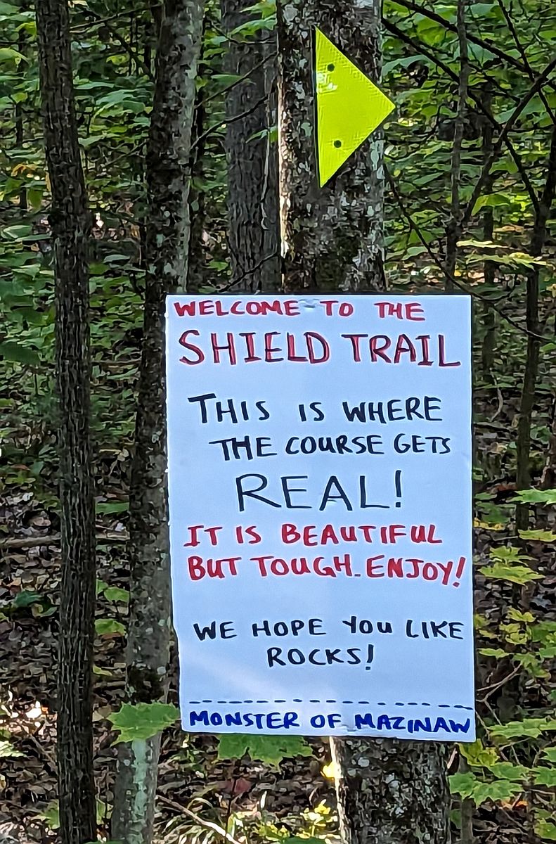 |
| This sign greeted us at the entrance to the loop, and I knew it was no lie |
I'm a little more comfortable than my companions on technical trail, so after letting some other runners through I ended up in the lead of our little pack.
 |
| The sunshine was gorgeous, but it was still pretty cool in the shade |
 |
| Rock-strewn downhill |
The hardwoods give way to pine forest for awhile, and I ran a bit to get ahead of my friends so I could...umm...contribute to the humidity levels of the forest..
 |
| ..and help prevent wildfires! |
The trail can be quite wet at times (and not just from feral runners peeing on it), so there is a boardwalk to help you cross a marshy spot.
 |
| More for ecological reasons than to keep your feet dry |
There are some whalesbacks of stone, too, that can be quite slick when wet.
 |
| This one has the massive root structure of a blown-down tree - a victim of the storms of 2022 - at its head |
There is quite a lot of evidence of storm damage throughout the Shield Trail, though it was far from being the hardest hit area of the park.
 |
| We'd see much worse as we got deeper into the course |
Conditions on the trail are highly variable depending on how much rainfall has occurred recently - we were lucky it had been quite dry, though not so much as to lead to a fire ban in the park. Nonetheless, as you reach the furthest point of the ~4km Shield Trail loop, Bon Echo Pond does intrude a little into your path.
 |
| A bit of boggy soil on this day - it was rather underwater the last time I'd seen it |
The view across the lake though?
 |
| *chef's kiss* |
You spend more than a kilometer of the course skirting along the water's edge, first of Bon Echo Pond and then..
 |
| ..after a decent climb over a ridge.. |
..you'll spend some time traversing a hill that borders Bon Echo Lake, once again through a pine forest.
 |
| It can be a little sketchy in places |
Of course, this is also where Kendra - the daughter of another runner, who volunteered to take photos on course when photographer extraordinaire Sue Sitki unfortunately was unable to make it due to a last-minute injury - set up, so some running for the camera had to happen.
 |
| I'd started with a gaiter around my neck and some dollar store "leg warmers" on my arms to ward off the morning chill |
The side-sloped, needle-carpeted section continues for awhile.
 |
| I was starting to regret not having filled my hand bottle |
Eventually it gives way to another hardwood-shaded climb over another ridge, as you begin to head back in the general direction of the doubletrack, away from the lake.
 |
| There's precious little flat ground on this trail |
If you think the slow going is over, I have bad news - it's more likely to get worse before it gets better. The last section of the trail in the clockwise direction is like one big rock garden, often obscuring anywhere else to put your feet.
 |
| For those of us without mountain goat blood, it warrants some caution |
 |
| I was grateful for companions who were willing to take things slow with me |
The technical nature of the course should make this a good compliment to the Haliburton Forest trail races - either using this race as a training run to get accustomed to rugged trails and longer times between aid stations (particularly when the full backpacking trail opens up and the course can take its final form), or using the 26k or 50k at Hali as a training run for the 30k or 60k here, though depending on your recovery 50k at Haliburton 2 weeks beforehand might be too much. My companions had both done the 26k on September 9th, 2023 - their first really technical race - and both Nat and Dee were adamant that they were happy to have had that experience before coming to Bon Echo for Monster of Mazinaw.
 |
| We stood aside to let all the speedy 10k runners - who had started half an hour later, but for whom the Shield Trail was the far point of their race - past us |
Successful negotiation of the technical portions rewards you with a delightfully sunny and runnable stretch of flat trail, absolutely festooned with wildflowers on both sides.
 |
| With a blue sky above to contrast the gold and auburn of autumn, and the sun chasing away the morning chill |
You arrive back on the doubletrack - where Dee & Nat needed to pause to water some trees, and for some odd reason I needed to go again - with a bit shorter downhill than you originally climbed, but it's quite runnable and leads back to the aid station.
 |
| Good thing, too, as I'd had to start rationing my last few sips of water |
I filled both bottles this time (Skratch electrolyte drink in my vest bottle), so I wouldn't run out again before the water drop. The next leg is a long stretch of rolling dirt road - the way to all of Bon Echo's backcountry campsites, on both Joeperry Lake and the Abes & Essens backpacking trail, as well as the front-country Hardwood Hills campground. None of these had been accessible when Tank and I camped in September 2022: the gate past the Shield Trail had been closed, blocking off the road completely.
 |
| This year it was wide open, and Nat ran away from Dee and I again |
I was starting to get quite warm as I huffed and puffed trying to catch up, so I decided it was finally time to ditch the arm warmers after gulping down a salt tab.
 |
| I wished I'd thought to do so at the aid station so I could just toss them to Tank - it was awkward to try to stuff them in the back of my little vest (the only place I had space, since I was carrying ~1,400 calories of food plus now a full bottle) |
We pushed further west, and the devastation caused by the storms became more evident as huge swaths of the road appeared clear-cut of trees.
 |
| With nothing to provide shade, the tubular gaiter around my neck needed to come off as well - I could just wrap it around my wrist, though, while I continued to chase Nat |
We were already starting to see the fastest 60k and early start 30k runners on their way back: Race Director Jeff had advised that anyone who got through their first lap and did not feel up to a second helping would be offered a 30k finish, so some of the former ended up becoming the latter. Some had a mis-step cause an ankle to roll or knee to tweak, some took tumbles, and some just decided that discretion was the better part of valour.
 |
| For my part, I was just trying to make good decisions for once, and not push things too far. |
We eventually reached the start of the Clutes Loop - the shortest one of the 3 loops that comprise the Abes & Essens Trail, and the only one currently fully open. There was a water drop at the entrance, but I still had quite a bit in my hand bottle and my vest bottle was full, so I didn't stop to fill anything.
 |
| Another runner - with whom we'd played leapfrog a bit so far - did stop to fill her bottles as we arrived. |
We started counter-clockwise on the Clutes Loop - so named because it takes you around Clutes Lake - with a decent climb on some not-too-technical trail.
 |
| We'd been out for 2 hours, but only made it about 11km so far |
Now into one of the hardest-hit areas of the park, the trail was strewn with downed trees through which a path had been painstakingly carved
 |
| ..by chainsaws |
There's a little stream that cuts across the trail, but with the low water levels of 2023 it didn't make for a difficult obstacle.
 |
| Left side is my view on approach, then right side is looking back as Nat & Dee begin to cross |
It was difficult to see some of the healthy trees that had been destroyed by the powerful winds
 |
| ..and also slightly difficult to climb up among the roots |
We hadn't left all the rocks behind on the Shield Trail, either.
 |
| Nat unfortunately bashed her knee a bit here |
We pushed further along over more undulations and through more fallen trees, finally coming to a beautiful view of Clutes Lake.
 |
| In all of its glory |
As one might expect from a backpacking trail, some bits are a little sketchy.
 |
| Not too big a deal in dry weather, but if it were wet it would be a bit hairy |
We reached a fork in the trail, with some signage that another runner was trying to figure out.
 |
| Blue sign at left: "Loop 1: Clutes Lake" (park signage) There is an arrow pointing right near ground level Sign on the tree (for the race) says: "Continue straight to the turn-around (about 1km)" |
I knew from the pre-race meeting (and the pre-race email - this part of the course hadn't been changed during the week leading up to raceday) that we were to do a 1km out-and-back on the Essens (second) loop of the backpacking trail, so I knew we needed to take the right fork and go out 1km, then come back again. The person who'd arrived ahead of us thought the sign meant to continue straight on the Clutes Lake loop, but I urged her to follow along with Nat, Dee, and myself to the turn-around.
 |
| So, up we went toward Essens Lake |
As with almost every Ontario Parks backpacking trail I've encountered, the second loop begins with a good-size rocky hill.
 |
| My friend Jeff for scale - he was on his way back from the turn-around |
The Essens loop definitely has no shortage of technical climbs - while most aren't particularly long, they take a bit of time, and you don't really get to make it up on the downhills as most mortals will need to be a bit careful about foot placement.
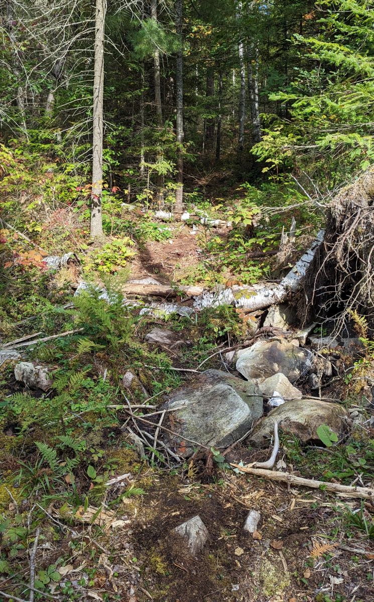 |
| It's a long way out if you hurt yourself, and there's no cell service to call for help |
Eventually, we reached the shore of Essens Lake
 |
| Looking resplendent in sunshine |
We also found another race sign
 |
| It says "Stop worrying about bears and enjoy the scenery!" I hadn't been worrying about bears...until now |
We kept puttering along on some pine needle-carpeted trail until - around 12.8km - we found a sign...and a box!
 |
| The sign says "You have reached the turn-around. We knew you could do it! Grab a pin from the container and then turn around. By the way, you look amazing!" |
We each took one of the adorable race logo buttons from the box
 |
| Heather's art is so delightful |
We pinned them to our hydration vests, and then Dee & Nat started talking about a picnic, so I pulled out the little zipper baggie of bacon I'd been carrying around in my pocket and offered it 'round. Nat took a tiny piece, Dee declined, and I chomped on a good-size slice as a pleasant change from all the sugar. Don't get me wrong: I love my cookies and candy while racing, and munched my way through 20 gummy peach slices, 8 gummy worms, 4 gluten-free Oreos, and 4 of my homemade maple crisp rice squares throughout the course of the day. It's nice to break it up with a little something salty, though, and since I'm allergic to potatoes I can't indulge in the chips that are so common at aid stations.
 |
| Fortunately, the scenery is allergen-free. This is the furthest point on the trail that was currently open - the rest of the Essens Loop has yet to be cleared of storm damage, and the Abes Loop (the longest at ~15km) has not yet been touched. |
So, back we went with our new buttons to prove we'd done the out-and-back (I wonder how many people might not have got one..?), looking at the last kilometer from the other direction..
 |
| ..which I quite enjoy, as you see things you miss when you only go one way. |
While it felt like the way out on Essens was all uphill, the way back proved that was a lie. Soon enough, though, we were passing the giant root ball of a fallen tree that had welcomed us when we set off from the fork in the trail.
 |
| Ok, neither Dee nor Nat is what anyone would call a big human (except in heart), but that root structure is a good 10'/3m high |
Back to the Clutes Loop, the sign on the tree and the arrow at ground level both indicated a right turn to continue along the loop.
 |
| It is worth noting here that future years of this race are unlikely do do the Clutes Loop - Race Director Jeff hopes to use the full Abes Loop by 2024, which will make this race measurably more difficult |
We headed roughly west, crossing a wooden bridge that spans a creek that drains into Clutes Lake
 |
| Where we met another runner who was unsure if he was going the correct way, which we confirmed he was |
I still can't believe what a gorgeous day we were gifted!
 |
| Between the weather and the colours, it was a stunner |
The rest of the Clutes Loop is no joke, either.
 |
| Not quite as challenging as Essens, but with its own rugged beauty |
We met up with the other end of the Essens Loop, with a closure sign strung across it by the park.
 |
| I didn't need to be told - that fallen tree would be a nightmare to try to climb through |
As we ambled along the Clutes Loop, I continued putting food in my face while watching my step.
 |
| It was the only way to stay upright |
It seemed to be taking awhile - not that we were in any hurry - but then some signs began to appear.
 |
| I'm almost certain that didn't grow there |
That 400 metres, though? You'd never believe how long it feels
 |
| Though it's so lovely you may wish it never to end |
Eventually, a glimpse of tent and the cheers of volunteers will filter through the trees
 |
| Which made me happy, as I'd once again run out of fluids. |
Note that this year's course only saw us do about 5.5km between the water drop (at which I hadn't filled) and AS2 - in future years, if the full Abes Loop is open and in use, it will be more like fifteen or more kilometers without aid, over rugged trails that prevent most people from picking up the pace.
 |
| A hydration pack with at least a 1.5L capacity is strongly recommended for 2024 and beyond! |
I got my bottles filled at the aid station, and both Dee and Nat filled with water and had a few snacks before we continued on along the dirt park road. We thanked the volunteers, who told us we had about a 4.5km out-and-back to do, then we'd return to their aid station before heading back toward the main park.
 |
| Reloading - Nat was also able to clean out the scrape on her knee and put a plaster on it |
I'd thought that the trip through the Hardwood Hills campground was actually a lollipop-style loop instead of an out-and-back, based on what I'd seen in the pre-race email and from talking to Jeff at race kit pick up the evening before, but I couldn't be sure. I'd just follow the signs and flags like everyone else!
 |
| Nat ran away on us again - that little dark speck is her at the top of the big hill up to the Hardwood Hills campground |
When I say big hill, I mean it's about the biggest one on the course.
 |
| The climb up to the Shield Trail might go on a bit longer, but it's not as steep |
From the moment you enter the campground - passing the closed gate, as this has not been re-opened to visitor traffic yet - the devastation of the storms is impossible to ignore.
 |
| I had heard from park staff last year that it looked like it had been clear cut, but I was still unprepared for the visceral reaction this brutal deforestation evoked |
The campground sits on a bit of a plateau, and I trotted along, getting some space on Dee - Nat was way ahead, so I had some time to try to get myself under control emotionally. It had been decades since I'd been out to this section of the park, but I remembered it being thickly forested.
 |
| Some portions retained a good measure of their former glory |
Others, however..
 |
| This is not the way I wished to see this |
There was one welcome sight, though: just as I realized I'd needed to pee again for awhile, a pair of vault toilets hove into view, and the door of the first yielded to my touch - unlocked! I availed myself of the luxury of a proper wee (with toilet paper and everything!), then popped back out to find Dee had caught up. She was concerned that we'd missed a sign as it had been more than 2.5km since we left AS2, and the "out-and-back" was supposed to be 4.5km.
 |
| We hadn't seen Nat coming back our way yet, either |
However, I had noticed a big auger at a fork in the dirt road (where signage had urged us to the right, around 17.5km) before we climbed another hill within the campground - as we ran down a hill toward a meeting of roads, I saw the same auger again, which confirmed that we'd done a loop. A little further yet, we caught up to Nat, and reached the gate through which we'd come.
 |
| There she is, heading around the gate |
Now on the park road again, we saw another race sign:
 |
| Sounds good! |
Well, mostly - I was a bit leery of how badly beaten up I might get running down the big hill from the Hardwood Hills campground. I'd messed up my back pretty badly (i.e.: could barely walk for a couple of days) a handful of weeks before raceday, and things were still a little sore and unpleasant at times. Banging down a steep hill might be a bit too much for it, so I tried to take it as carefully as I could. This meant I had to just run whatever pace was comfortable, and I ended up getting away on Dee and Nat a bit as I just let my legs turn over however they felt best.
 |
| We hit the 20km mark near the bottom, at around 4h20m |
We passed both AS2 and the water drop as we headed back along the dirt road toward the Shield Trail.
 |
| Which was NOT - contrary to what any race signage might have you believe - all downhill! (And if you spot a dark speck, that's one of the 60k leaders heading out toward his second Clutes/Essens loop) |
The way back along the dirt road felt very long, but somehow my legs had got the hang of this running thing - and my back wasn't complaining too much - so I trotted along pretty consistently. I'd joked with someone before the race that I had 15k to warm up and 15k to actually run, but here I was now passing 22k and finally trucking along quite well.
 |
| Maybe I just didn't want to look at the storm damage anymore, as it was highly evident along the road as well |
I was getting away on Dee and Nat now, but would stop periodically to let them catch up.
 |
| And, of course, to take some photos of my beautiful friends |
My watch said 4h51m by the time I rolled back into AS1 at around 23.5km, ready to take on the Shield Trail once more.
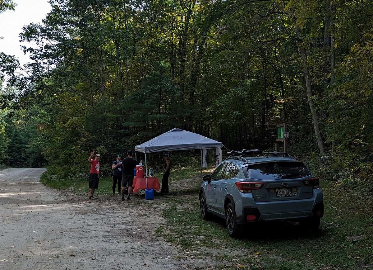 |
| With just my hand bottle filled again, and a few sips of cola for a caffeine + sugar hit |
I'd discussed with Dee and Nat that I'd like to do the Shield Trail counter-clockwise on our second go, for a few reasons: first, that we'd see stuff that we might have missed going clockwise on the way out; second, that we'd do the rockiest section first, before too much more fatigue set in; and third, that we'd have a longer downhill off the end of it, with less of a climb up to begin the loop.
 |
| They both said they were just happy to follow me whichever way I went, so we took the right-hand fork when it appeared and ignored the "wrong way" sign |
I hadn't anticipated so many other people being on the trail while we were out there, all of whom were going in the other direction: most were 30k runners that had done the noon start, with a handful of 60k runners on their second lap, plus a few hikers.
 |
| Almost every single one of them, though, asked if they were going the wrong way! |
I explained that we'd had the option to do the Shield Trail in reverse on the second loop - that it had actually been the original intention, but they thought it would be too confusing (which was proving to be the case even with most people not doing it!), so let people choose.
 |
| Orange arrows are outbound - yellow arrows are inbound. The royal blue dots are the aid stations, and the paler blue dot is the water drop. |
I was getting away on Dee and Nat again a bit through the rocky section, but when I tried to stop to wait for them the few remaining mosquitoes in the park tried to swarm me, so I had to keep moving to keep them at bay.
 |
| To be honest I was partly happy I wasn't doing the 60k because I wouldn't want to be here at sunset due to mosquitoes, and would be rather unhappy about trying to negotiate this in the dark. |
I was happy to move quite slowly, though, as it turns out there really isn't a soft option for direction on the Shield Trail.
 |
| It's just a rooty, rocky, side-sloped beast no matter which way you choose to tackle it |
I did have to run some, though, as it turned out Kendra was still hanging out with her camera.
 |
| 5hrs in and still just enjoying the heck out of the gorgeous trails! |
The side slope felt sketchier moving counter-clockwise when it was death-to-the-right versus death-to-the-left, but I can't honestly gauge whether that was because I was a little more fatigued or if it's just a side preference.
 |
| Regardless, I ended up putting a hand to the uphill beside me for a sketchy bit, and would have been happier if I'd had a pole or two |
Soon we descended down to water level again, for the shoreline traverse of Bon Echo Pond.
 |
| I quite enjoyed the different perspective that the counter-clockwise loop offered |
The boggy spot had got a bit more mooshed up by the passage of runners' and hikers' feet since our traipse through in the morning.
 |
| ..but was still perfectly possible to get through with dry feet. |
Coming toward the end of the loop, I realized that I'd forgotten there was another rocky section (though slightly less boulder-laden) before you reach the doubletrack.
 |
| Right up to the very end |
Soon enough, though, I hit the doubletrack and began to run. I wanted a bit more water for the final ~3k (as I was out again - it was much warmer than the first time 'round, the high for the day being a summerlike 22c/72f), so I didn't feel too bad about leaving Dee and Nat to make the descent to the aid station in their own time, as it would take me a few moments to replenish my hand bottle.
 |
| It's not completely downhill from the end of the loop if you go counter-clockwise, but it's relatively flat and runnable |
I found my honey waiting for me at the trailhead, and cruised in to get my last bit of water.
 |
| I may have also stolen one final smooch, though I'd be back out to this AS after I finished to volunteer until the end of the race |
Once Dee and Nat were with me again, we ran along the road under Hwy 41 until we reached the entrance to the new trail back to the woodyard.
 |
| Looking very ad-hoc from this end |
This, again, was quite slow going. While my legs had plenty of life left in them, the uneven ground was still strewn with rocks and riddled with hidden holes, so I walked most of its ~750m length.
 |
| I didn't need to snap an ankle now |
Soon we reached the woodyard, then out onto the paved road.
 |
| The left-right jog, in reverse this time - turn at the multi-coloured teardrop flag |
 |
| Another look at the stunning fall colours |
We veered left off the day use road, back onto the Bon Echo Creek Trail.
 |
| Where I'd barely been able to run for more than 10sec at a time in the morning |
I was still feeling quite peppy, though it had now been six and a half hours since we set off.
 |
| You know you're an ultrarunner when you feel better at 29k than at 2k |
Now that we had it to ourselves, I was able to better take in the lovely scenery of the trail.
 |
| Without getting in anyone's way, or having to step aside to let people pass |
Nat and Dee talked about how we should all finish together - the three skirts - as we'd spent the whole race together.
 |
| I was totally down for that - it had been a fun day with them! |
Soon the end of the trail hove into view, with our first glance at Mazinaw Lake since morning.
 |
| It still seems weird to me that a race in Bon Echo doesn't include a single view of Mazinaw Rock |
Coming off the trail, I settled into an easy trot, but was quickly annoyed when an uncontrolled dog came running straight toward me - I wasn't sure if I could avoid kicking it, as it came right for my legs. I swerved as best I could, saying to its pursuing owner "This is not an off-leash area", to which she retorted that yes, it was. In either case I was too far past her now to continue the discussion, and headed in to the finish.
 |
| The chute was in view |
I ended up coming in about a minute ahead of Nat & Dee, partly because I was rolling along pretty well on the final grassy section, and partly so I could set myself up to get a photo of them coming in together.
 |
| They're the real rockstars - I was just their goofy tour guide |
Official time: 6h51m44s @ 13:45/km
59/63 O/A - 29/33 Women - 11/12 W40-49
(Official results are here - Garmin data is here)
 |
| (This was at the turn-around on Essens, just after we pinned on our buttons - let's just call it our finish photo together) |
I got my medal and grabbed my bag - plus an Orange Crush, which I haven't had in years! - and got the obligatory post-race pic.
 |
| The wind had really picked up - I was glad we weren't trying to paddle today! |
With all my gear from the start/finish, I started the walk back to our campsite so I could change out of my wet gear and grab a shower at the comfort station - I'd providently left toiletries and a towel at the campsite (since Tank had the car at AS1), plus my bag of clothes was in the tent.
 |
| I took a couple of shortcuts, but followed a good chunk of the Shoreline Trail |
As I was leaving the race site, though, I saw the sign: "Dogs may be off-leash in this area". Whoops - I felt really foolish, and wished I could have apologized to the lady whose dog ran at me.
 |
| She wasn't there when I was walking back, but Mazinaw Rock was in all its glory |
Changing out of my sweaty kit after the ~2km stroll back to camp, it was like I'd barely run at all: my feet emerged from my shoes with nary a blister or hotspot, and just a bit of dust from the dry trails. I found a spot of blood on the back shoulder of my shirt where a days-old mosquito bite had been rubbed raw by my vest, but it wasn't painful and I had no other chafing at all. It felt strange to finish a race with a still-functional body, and without much real fatigue. If I'd needed to do another 10km, I wouldn't have flinched.
 |
| As it stood, though, I had volunteering to do after I got cleaned up! |
Tank came to pick me up - I messaged him when I was getting dried off, and we both arrived at the campsite at the same time - which worked out well, as that meant I could grab a packet of instant noodle soup from the car to make some hot food. I had the stove at camp with me, but nothing to put on it without the vehicle! I made the soup plus a cup of hot chocolate, and carefully sipped while Tank drove us both back out to the aid station. As it happened, there were very few runners left on course by the time we got there (around 6pm, with the race cut-off at 8pm), and within an hour the last one was finished.
 |
| So I mostly just sat in a chair at the AS and yelled "WOO" a lot |
When the last runner was done, we packed everything up with the help of the two other volunteers, and loaded the perishable foods (that we didn't want to leave in the open for animals to get into; that's not good for them, or for the park) into our car to drive back to the day use area.
 |
| Seeing this beautiful young deer beside the day use road on our way |
The sun was setting by the time everything was torn down and loaded up in the van, and the day's heat was rapidly slipping away.
 |
| The thin cloud cover made for a gorgeous sunset, but did nothing to trap warmth |
Back to the site after thanking the volunteers and organizers - all the wonderful people who work so hard to put on these fantastic events, chopping wood and carrying water so we can go play in beautiful places - to make dinner and light a fire.
 |
| We got great firewood at the park this year, too - nice and dry, but doesn't burn too quickly! |
It was gone midnight by the time I got to bed, but I awoke long before my alarm in the half-light of morning. Since I needed a trip to the comfort station, I ended up wide awake, so made myself a cup of hot chocolate and went for one last walk to the boat launch.
 |
| I didn't even have time to steep a cup of tea - I'd have missed it |
 |
| No mist this morning - it was too breezy for it to form |
Then it was back to camp one final time, to make breakfast and pack up. I can't think of a more wonderful way to have spent an extra-long weekend, and I look forward to next year, though I know the course is likely to hold far more challenge!
 |
| When the campground roads of the Hardwood Hills are replaced by the Abes Loop of the backpacking trail |
I don't know about you, but I'll be there with poles on!


