If we thought ice climbing had been a workout, were we ever in for a day today!
 |
| Though things were definitely looking...up |
Having parked up and camped at its foot (well, really the foot of Meall an t-Suidhe, which at 2,333ft is only just over half the height) on Monday evening, I found what looked like a window of good weather on Tuesday from late morning to mid-afternoon, with the rest of the week looking a bit iffy. That meant we'd just have to shoot our shot with no further time to shake off the jetlag: the summit of Ben Nevis was the goal, via the Mountain Track.
 |
Also known as the Tourist Track or Pony Track
(3D map from TalkyToaster) |
The day was predicted to start rainy until 11am, so we slept in til 8:30...but then awoke to sun breaking through the clouds!
 |
Remember: this is just the little brother mountain, Meall an t-Suidhe (Hill of the Seat, or Hill of the Rest).
It doesn't even qualify as a Munro |
Something I'd emphasize to Tank over and over again on our holiday was "if you want to do big things, you need to eat big food", so I cooked us up a hearty brunch of haggis and eggs on toast.
 |
| ..washed down with Tanker's amazing coffee. |
We got ourselves properly dressed for "hillwalking" - stout hiking boots, trousers, longsleeve wool shirts, and plenty more clothes - including Gore-Tex jackets and waterproof pants, plus a synthetic puffy jacket, fleece, insulated vest, and tubular neck gaiter each - in our packs. While it was predicted to reach 17c/63f at ground level in the afternoon, it was only about 13c as we started off, and the high for the summit was expected to be 8c/46f...with a wind chill of -1c/30f!
 |
| We were also sporting along sunblock, bug spray, an emergency light/beacon, trekking poles, 4L MSR Dromedary bag of water, plus a 1L Nalgene of water each, a 10 essentials kit each with first aid, compass, whistle, matches and firelighters, a glow stick, and an emergency blanket, and our packs held a fair assortment of snacks to eat along the way. |
Duly loaded, we set off just before 11am from the door of our own campervan to walk up the Ben.
 |
| We hoped to take less than 4hrs to reach the summit, as cloud was predicted to descend on the mountain by 3pm with very poor visibility |
The first part of our day was utterly flat and not particularly scenic, walking out of the caravan park up Glen Nevis Road to the Glen Nevis Visitor Centre so we could cross the bridge there over the River Nevis (Nibheis being its Gaelic name, meaning venomous).
 |
| Tank leading the way |
 |
| Looking north - downriver |
 |
South up the glen
(which means valley, particularly with a river running through it) |
A right turn off the end of the bridge onto the Nevis River Path - a flat, groomed trail that follows the river past endless fields of sheep.
 |
| We were set to take a bleating! |
You shortly come to an intersection, which couldn't be signed more simply:
 |
| Left turn for us |
From here the path remained groomed, but began to climb gently past Achintee Farm and the Ben Nevis Inn (which is what people mean when they talk of the pub at the bottom).
 |
| The ascent begins! |
As you reach the intersection of the path to the inn at the end of the stone wall, you encounter a stile.
 |
| I hadn't seen one laid out quite like this before, but there again I don't often encounter big flocks of sheep in Ontario |
A few yards further on, the crossing of the path.
 |
| The cairn holds a donation box to assist with maintenance of the path - had I brought any money with me, I'd have dropped some in! |
From this point on - with one minor exception - your easy, pleasant stroll is over for the day. The path begins to climb significantly, mostly via the expedient of stone steps. |
| While there had been no rain that morning, the path was wet in many areas from the bit of rain the night before |
We came to another stile - the one we'd seen people stopping at from the van, parked down below - and gazed back at how far we'd climbed already. |
| Mindy was down there, off toward the right |
 |
| The view down the glen was getting a bit more dramatic |
The sunshine was absolutely beautiful, highlighting the streams cascading down the mountain. |
| It's not just the incline that will take your breath away |
Some of the streams also crossed the path on their way down, which meant that on a rainy day you'd definitely want waterproof footwear. |
| Tanker on the stepping stones, which would easily be submerged by snowmelt or the usual rain |
It took us about 45mins to reach the first of the switchbacks, with pauses along the way to take photos or to drink some water. |
| If the prior photos made it look like we were alone on the path, they were misleading - there were loads of people of all ages and levels of preparedness out on the trail |
 |
| The wet stone steps continued, even with no visible source to feed the puddles |
 |
| ..and then there were the sections that were definitely not steps. |
I believe this was about the time I pulled out my trekking poles, as the path just seemed to get steeper and more technical. Keeping in mind this was just 2.5 weeks after Sunburn Solstice, which was most definitely not enough time for me to fully recover from seven and a half hours of running in high heat - I definitely felt like I could use the assistance of my wimp sticks!
 |
| The stone almost turned to giant cobbles for awhile |
 |
| Crossing the bridge just before the turn up the flank of Meall an t-Suidhe - through the first 4 switchbacks now! |
Rounding the flank and starting the push up to Lochan Meall an t-Suidhe - about an hour in - is where Tank started to flag a bit.  |
| Poor dude had no idea what he was in for |
I had tried to gently nudge him in the direction of doing some targeted training for this over the past couple of years, and he reassured me that he'd done lots of walking with his folks (who'd come to visit for the week before Sunburn Solstice)...but since his mum is no longer up to even walking a full 9 holes of golf, I was a bit skeptical about how prepared that would leave him to climb 1,345m/4,413ft from sea level in a day. I held my peace, because there was nothing that could be done.
 |
| We'd just have to stop when he needed, so he could catch his breath |
 |
| It's not like I was moving particularly quickly over the technical trail, anyway! |
 |
| ..and I certainly wouldn't complain about having time to take in the view. |
Reaching the top of the switchbacks on Meall an t-Suidhe brings you to a pleasant reprieve - a groomed, gravelly trail that leads to the lochan.
 |
| It's still uphill, but easily walkable |
We arrived at Lochan Meall an t-Suidhe (lochan meaning small lake) - known as "the Halfway Lochan" despite it not actually being halfway - in about 1h45m, and stopped to take off packs for a moment so I could put on some additional clothing. The sun was still bright, but now at approximately 600m/1,968ft the wind and altitude had me feeling chilly. |
| Looking back the way we'd come, over the shoulder of Meall an t-Suidhe |
 |
| I was not even remotely tempted to go for a swim! |
Heading onward and upward, our next "checkpoint" was the actual (or accepted) halfway point - the Red Burn (burn meaning creek or stream), which tumbles down the flank of Ben Nevis itself, across the Mountain Path. |
| As seen here |
It was beautiful in the sunlight, and I could only imagine what a raging torrent it must be in the spring when the meltwater comes rushing down. |
| I certainly would not be standing in the same spot |
It was now just past 1pm - we'd been hiking for about 2 hours, and they advise that your time to the Red Burn is a reasonable way to estimate your time to the summit.  |
| We were now into the main set of "zig zags" (switchbacks) that would lead to the summit |
 |
| ..but we still had a long way to go yet. |
The trail was getting much more difficult - gone were the rock steps, replaced by just...rock. Chunks of all sizes jumbled and strewn about, so many of which would move underfoot when you stepped on them. Of course, at this point, I needed to have a pee, which was made simpler by the fact we were no longer anywhere near a water source (other than our Nalgenes, which we'd already refilled once from the 4L drom bag). As one review on TripAdvisor reads "There isn't anywhere private to pee so you just have to go with it. We've all got a bum it's not a big deal to get it out." So, I found a bit of a concavity between a couple of rocky outcroppings beside the trail, and had myself a wee.  |
| With an estimated over 100,000 people climbing the Ben each year, it's just expected that one looks the other way should someone else feel the call of nature |
We had a snack as well - some delightful chocolate covered macaroons - and a gulp or two of water before continuing. Tank had got his poles out at the Halfway Lochan, but continued to struggle with the relentless climbing, stopping every few minutes to lean on his poles and try to settle his breathing.
 |
| I'd find myself getting away on him a bit |
I actually feel quite bad about the lack of real encouragement I gave Tank as he toiled up the mountain - I was a bit concerned about him, and wondered if maybe we wouldn't be better off to turn back rather than push him to a point he could get hurt. At the same time, I didn't really want to express that to him as I didn't want to discourage him. So, I just tried to make suggestions - shorter steps, trying to control inhales and exhales by using a 4-count for each - and worried a lot.
 |
| We still had a long way to go, too - what you see up there is not the summit |
The going was certainly not easy for me, either. I had less trouble keeping my breath in check, but - clumsy oaf that I am - I found the steep, rocky trail quite a challenge. |
I am no mountain goat.
I'm more like a groundhog. |
 |
| The views were quite impressive, though, and we came to do the thing |
Onward and upward, with the trail getting yet more uncertain underfoot as the last shreds of vegetation dropped away below us.
 |
| ..and the path made it look like you just jumped off into the sky. |
Despite his lack of fitness, Tank was a trooper: we'd come to climb the highest mountain in the UK, and dammit all that was what he was going to do.
Unfortunately it looked like our clear weather window at the summit was evaporating as the cloudcover began to descend upon us.
 |
| With no real familiarity with the weather patterns in this part of the world, I had no idea whether this was a portent of worse conditions to come |
The trail now was basically just loose shale underfoot, with nothing but shattered rock around and large cairns to mark the path through fog or in winter.
 |
| Snow is to be expected covering the Mountain Track from September to May each year, and it has been known to snow at the summit in July and August |
By 3h45m - with a momentary break in the cloud - we could finally almost see the actual summit.
 |
| I did not envy those folks in shorts |
As we continued to trudge upward, we even spotted a bit of snow off the track a bit.  |
| We actually had some lightweight spikes with us in case of snow, too, but saw very little. |
Past all of the zig zags now - they'd been reducing in width as we climbed - the track becomes one last long slog to the summit plateau.
 |
| Just a teensy bit sketchy |
 |
| I guess I was getting away from Tank again |
 |
| He was still gamely trudging along, though |
It's easy to see how people can become lost and get seriously hurt or killed on this mountain every year. The summit is only clear about 30-35 days per year - less than 1 day in 10 - and some of the people we saw making for the summit were quite poorly prepared. If you're unable to see well enough to keep yourself on the path, you could get yourself into quite a bit of trouble.
 |
| There's an absolutely jaw-dropping view hidden in cloud out there, but also a 610m/2,000ft drop |
 |
| Part of a safety pamphlet |
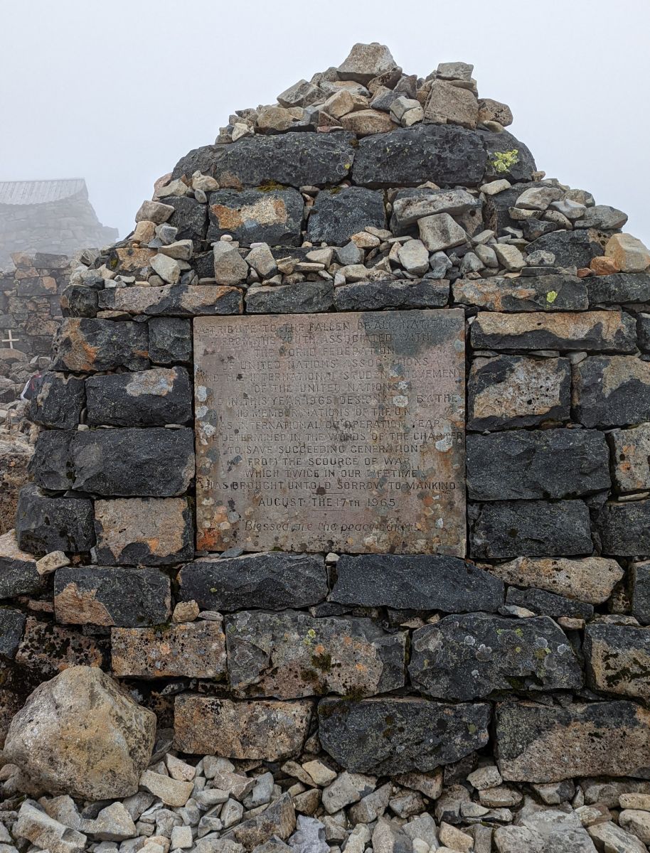
Now finally on the summit plateau, we saw the large cairn erected as "A tribute to the fallen of all nations from the youth associated with the World Federation of United Nations Associations and the international student movement of the United Nations , who in this year 1965 designated by the 113 member nations of the U.N. as National Co-operation Year, be determined in the words of the Charter to save succeeding generations from the scourge of war, which twice in our lifetime has brought sorrow to mankind. August the 17th, 1965. Blessed are the peacemakers"
 |
| I swear there's a cairn for everything in Scotland |
There were quite a lot of people up on the summit, which we reached just before 3:20pm - about 4h25m after setting off.  |
| Summit trig marker to the left, emergency shelter rear right, and the cairn photobombing at front right. |
Tank was a bit overcome at having made it - he hadn't told me previously that he'd been told by a doctor ages ago that his lungs wouldn't permit him to summit mountains, but here he was! The wind was absolutely howling up there, and it was very chilly in the damp air. A lot of people either went and hid behind crumbling bits of rock wall, or started back down. Soon the trig marker was actually deserted for a moment so we could get a couple of photos.
 |
| The trig point sits on top of a cairnlike rock platform |
 |
| Way to go babe! |
A friendly fellow hillwalker offered to get a photo for us:
 |
| Fun times! |
I was starting to get a bit chilly, and needed some food - I urged Tank to eat as well.
 |
| He wandered over to the far side of the emergency shelter to snap a photo of this veteran memorial flag on the summit |
At 3:50pm we finally set off again with full Nalgene bottles and a bit of a snack in us. I might have stayed longer, but I still wasn't at all sure what the weather had in store for us. If we were in cloud all the way down, or it started to rain, it would be a very treacherous descent for us.
 |
| My Garmin wasn't at all sure we'd climbed the full 1,345m, but I'm gonna go with the trig point's opinion on this. |
I was keenly aware that more people are likely injured on the way down than on the trip up - we'd actually seen a few people basically blow out a knee while descending as we climbed. Sometimes it's just getting worn out that leads to a mistake, and sometimes it's that sense of accomplishment at reaching the summit that makes you careless. Either way, we'd need to take it easy on the way down.
 |
| And mind our path |
I found the descent more difficult, really, than hiking up - the shale was loose and sketchy feeling underfoot, which is not a bueno thing when the track is steep and rocks keep rolling and slipping out from under you. I was getting tired - I think I'd have benefited from some more calories, less jetlag, and a bit more post-ultra recovery - and feeling clumsy.
 |
| Pictured: a beautiful but absolutely terrible place to feel clumsy |
Part of it was my boots: they're very stiff and have big, chunky heels to them, which I'd catch on the rocks as I clumped downhill in them. I'm used to tackling technical terrain in trail running shoes, which flex with my foot and conform to surfaces a bit to give the lugs maximum bite. Everything I'd read said stiff, supportive boots are best, and I will admit that they may have saved me turning an ankle here and there, but I felt like I sacrificed a lot of agility at a time that I really could have used some heckin' agility.
 |
| Sunbeams tho |
It was also a strange time for me to encounter the British greeting of "Are you alright?" I didn't know this was meant more in a "Hey, how are you doing?" way, and probably confused the heck out of a couple of people by responding with "Yeah, getting along ok." The shale finally gave way to larger rocks that were a bit more solid underfoot, and we made decent progress - it took us about 1h40m to descend back to the Red Burn, in noticeably less sun this time.
 |
| Having now been out for six and a half hours, I was ready to be done |
I'd talked to Tank already about cutting our trip back a little shorter by using the youth hostel side trail below the last of the lower switchbacks, as it led right into the back of the caravan park at which we were camped (the youth hostel being part of the Glen Nevis estate, operated by the same people). He was fully in favour, so we just tried to make our way down as best we could.
 |
| I greatly appreciated this groomed section by the Halfway Lochen after the sketchy descent from the summit |
Unfortunately I found the trail increasingly challenging to descend. I think apart from my unfamiliar boots, I relied too heavily on my poles, spending too much time trying to get a solid plant when everything around was rocky. The switchback on the side of Meall an t-Suidhe below the lochen made me feel very exposed as I turned away from the hillside to seemingly walk off the side of a cliff.
 |
With - notably - sheep just meandering up the side of it.
Wooly little jerks made me feel like a chump! |
Descending further into the trees, the trapped heat hit us like a wave, and we had to zip down our vests as we both began to pour sweat.
 |
| So lush and green after the bleakness of the summit |
The lower switchbacks proved more challenging on the way down, now with quite sore legs and just utterly worn out.
 |
| Someone could make a million dollars if they ran a cable car down from the summit, or even the Red Burn |
Eventually we made it to the intersection of the youth hostel trail at almost exactly 7pm. We sat on a wooden beam and took off our vests, stuffing them in our packs and taking a good, long drink of water. Then it was packs back on, and into unknown territory as we started down the rock-cobbled path.
 |
| One last good look down the glen |
So it turns out what I'd feared about the hostel path was true: instead of dropping 180m/590ft over 2.5km/1.5mi, we'd now do so over 600m/656y.
 |
| This could be a terminally quick way down |
My boots, once again, caused me grief: every time I'd come to trust them a little on the sloping rocks, they'd slip enough to terrify me again. I whinged. I minced my way down. I'm sure Tank would have been well back to the van and into a beer an hour before I finally managed to pick my clumsy way down that stinkin' rockpile.
 |
Looking back up the hostel path.
My adductors and quads were just wrecked by this point |
At long last, the trail smoothed out to gravel and we finally found ourselves on level ground again.
 |
| Hallelujah! |
One more bit of climb to get up on the bridge:
 |
| And another stile |
 |
| Crossing the river once more. |
From there, it was only another half-kilometer walk or so through the caravan park back to the van. We arrived at 7:40pm - our
full transit time for the 16.76km recorded by my Garmin was 8h44m, and while my legs were sore and I was very tired, Tank was absolutely ravaged by the descent. It would take weeks before his left leg would actually heal enough not to pain him daily. For myself, I'm happy to have climbed Ben Nevis once (even if the view at the summit wasn't worth the price of admission), but I don't think I'd do so again. The views are lovely on the way up, but we lucked out with a very good day, and there are so many other gorgeous places to explore that don't involve plodding (and slipping, and nearly falling) through a wasteland of shattered rock.
It's definitely no joke, though, and I hope some of the people we saw made it off ok considering how beaten up we were. To be honest, if you look from the other side of the range, it's absurd to think that you can just walk up this beast of a mountain.
 |
| That looks like something on which even the sheep would rope themselves together |
In any case, I'm incredibly proud of Tank for toughing it out, and grateful to him for his patience with my timid arse as I tried to so daintily pick my way down. Next time I'll try trail shoes!
 |
| At least there was sunshine and good company! |
Let me tell you that stepping in and out of the back of the van was a trial for the rest of the evening: my poor legs had been beaten up badly by the unforgiving rock steps on the way down, and my quads were complaining loudly about ill use. I was as hurting as if I'd just run an ultra, but the whole trip had only been just over 10 miles!